
Loading panorama viewer ...
Configuring ...
© 2006 Norman Peters, All Rights Reserved.
Caption
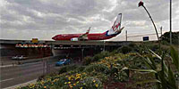
Botany Bay is the site of the first landfall in Australia of Captain James Cook in April, 1770 (at Kurnell on the bay's southern headland) during his first circumnavigation of the globe. It is also the site of two of the runways of Sydney (Kingsford Smith) International Airport - the main north-south runways extend out about 2.5 kilometres into the bay on reclaimed land. Kingsford Smith is the world's oldest continually operated commercial airport, and is the busiest airport in Australia, annually handling over 28 million passengers. In 1953, it was recognised as the busiest in the world outside the United States.
The main 4 kilometre north-south runway built in 1963 (and extended in 1968 for large aircraft) crosses over a main arterial highway that links the southern suburbs of Sydney with the city, that is just 10 kilometres away. This panorama shows the juxtaposition of air, road and foot transport, where cars and planes move within just 5 metres of each other.
You can see three aircraft in this panorama: one on the runway over the road tunnel; one having just taken off to the north; and, another in the distance about a minute ahead of that aircraft.
The panorama opens facing west. To the south, across the roadway (but not visible) is Botany Bay, less than a kilometre away, where much commercial shipping activity occurs. A railway services passenger traffic to and from the airport, making this location one where most forms of public and private transport converge.
To the east you can see one of the airport control towers, from which I had a creepy feeling of being watched. Perhaps that was because I was taking photos at the boundary of one of the most secure transport hubs in Australia.
On the day I shot this panorama, Sydney was in the grip of a Spring heat-wave - it was 35 degrees C, with wind speeds of over 100 km/h making the conditions for panoramic photography near impossible - my tripod almost blew over in several of the heavier gusts. The light was changing moment by moment from full sunlight to cloudy darkness because of the wind speed.
Location
Australia - New Zealand / Australia
Lat: 34° 57' 44.88" S
Long: 151° 10' 46.2" E
Elevation: 6 metres
Precision is: High. Pinpoints the exact spot.
Equipment
Canon 10D, Canon 15mm fisheye, tripod mounted, shot at 100 ASA, exposure 1/500 second at f9. Two rows of 10 portrait exposures, plus zenith and nadir. Stitched with PTGUI 5.8.4. QTVR produced with PanoCube Pro.
 Tap or click the zoom icon in the bottom right corner of the picture to switch between in-page and fullscreen view