

Loading panorama viewer ...
Configuring ...
© 2008 Miguel Sepúlveda, All Rights Reserved.
Caption
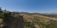
Ronda sits on a rocky plateau at 739 meters above sea level. It is divided into two parts by a cannon, known as the Tajo de Ronda, which runs the river Guadalevín Guadiaro River tributary. After the throat of the pit itself also extends the pit on the Valley Mills. To the east of the city is the natural park of the Sierra de las Nieves, south Genal Valley, west of the Sierra Grazalema and other lands to the north in the direction of more flat Campillos.Ronda se asienta sobre una meseta rocosa a 739 metros sobre el nivel del mar. Está dividida en dos partes por un cañón, conocido como el Tajo de Ronda, por el que discurre el río Guadalevín afluente del río Guadiaro. A continuación de la garganta del tajo propiamente dicha también se extiende el tajo sobre el valle de los Molinos. Al este de la ciudad se encuentra el parque natural de la Sierra de las Nieves, al sur el Valle del Genal, al oeste la Sierra de Grazalema y al norte otras tierras más llanas en dirección a Campillos.
Equipment
Olympus E-1, Zuiko digital 8 mm fisheye
Manfrotto 303 SPH Panoramic head y tripode mod. 075
PTGui, Pan2QTVR Gui, PhotoShop CS3
 Tap or click the zoom icon in the bottom right corner of the picture to switch between in-page and fullscreen view