
Hilton Falls Conservation Area
Along the Niagara Escarpment in Southern Ontario, Canada
June 21, 2005. 22:20UTC (18:20 EST)

Loading panorama viewer ...
Configuring ...
© 2005 Francis Fougere, All Rights Reserved.
Caption
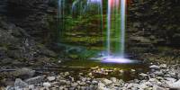
Sixteen Mile Creek and the Niagara Escarpment
Two tributaries of the Sixteen Mile Creek wind their
way through the wooded and rocky landscape of
Hilton Falls. One creek cascades over the escarpment
forming a beautiful 10 metre waterfall while
the other creek flows through a series of beaver
ponds into a 35 acre reservoir that was built in 1971
for flood control and stream flow augmentation. The
heavily forested park is situated on Ontario's Niagara
Escarpment, which winds 725 km from Queenston
to the islands off the Bruce Peninsula.
The Niagara Escarpment was formed 450 million
years ago along the shore of a shallow tropical sea
that covered a vast area of Ontario and Michigan.
Skeletons of primitive sea creatures and debris from
ancient mountains were compressed into massive
layers of reef and sedimentary rock. These ancient
coral reefs formed a layer of amabel dolostone to
create the cap of the escarpment. Beneath this
layer are soft, easily eroded shales. Over
succeeding millions of years, erosion, glaciers,
ancient rivers and lakes, and the elements shaped
the escarpment into its distinctive craggy cliffs and
rugged slopes that can be seen today.
completes its loop down a steep hill and across
the Hilton Falls dam back to the start of trails.The Sawmills of Hilton Falls On the brow of Hilton Falls the remains of three 19th Century sawmills can still be found. The first mill was constructed by Edward Hilton in 1835 and supplied Nassagaweya Township with lumber. Unfortunately, Hilton supported William MacKenzieís abortive rebellion in 1837 and had to flee to the United States and leave his mill to fall into disrepair. It wasn't until 1856, when George Park acquired the property that Hilton Falls once again became the site of an active mill. The substantial stone ruins that exist today, indicate that a well-built mill building and dam were constructed by the Ancaster doctor. Records indicate that an immense 40 foot diameter water wheel powered the mill. Park sold his operation in 1857 and it burned down in 1860. Virtually nothing is known about the third and last mill constructed by John Richards. It began operation in 1863 and continued until it burned in 1867. After the final mill burned, the water power of Hilton Falls was no longer used.
Halton Conservation Area http://www.conservationhalton.on.ca/hilton.html
Francis Fougere http://www.fougere.ca
Location
Lat: 43° 30' 34.8" N
Long: 80° 59' 45.3" W
Elevation: 779 FT.
Precision is: Unknown / Undeclared.
Equipment
A Canon 20D with a Canon 18-55mm lens set at the 18mm setting was used on a Kaidan Kiwi+ pano head. The panorama was stitched together with RealViz Stitcher V4.
The shot of the falls consisted of three time exposures taken through sharp cutoff filters in red, green, and blue. The shots were then combined in a composite to create the rainbow effect in the flowing water over the falls and then blended into panorama that you see.
This panorama was shot with available light at 1/6 of a second @ f 5.6 in Raw mode on the Canon 20D. I used a Kaidan Kiwi+ pano head and made a series of 18 scenes or photographs. I processed all the images in the RAW conversion software Capture One Pro V3.7 from Phase. This software allows me to set the white point balance, drop the contrast, adjust the colour saturation, and fine tune the exposures before I create pixels. This process allows for a better workflow and cleaner files then correcting in PhotoShop. The images are then stitched together in RealViz Stitcher and the QuickTime panoramas are then converted from the flat tiff images.
 Tap or click the zoom icon in the bottom right corner of the picture to switch between in-page and fullscreen view