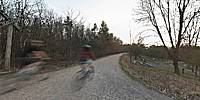

The Bruce Trail and the Rail Trail
Hamilton Ontario, Canada
March 21, 2012, 18:55 EST

Loading panorama viewer ...
Configuring ...
© 2012 Francis Fougere, All Rights Reserved.
Caption
The Bruce TrailCanada's oldest and longest footpath, provides the only continuous public access to the magnificent Niagara Escarpment, a UNESCO World Biosphere Reserve. It is one of only fifteen such reserves in all of Canada. The main Bruce Trail runs for 885 Km from the Niagara river to Tobermory at the end of the Bruce Peninsula.
In 1960 the idea of a public footpath spanning the entire Niagara Escarpment was born. Never before in Canadian history had a trail of this scope been realized. The first meeting of the Bruce Trail Committee was in 1960. The four members attending: Norman Pearson, Ray Lowes, Dr. Robert MacLaren and Philip Gosling, each became instrumental in building the Bruce Trail.
Gaining access to the Niagara Escarpment was the critical first step in building the Bruce Trail. From 1960 to today, Escarpment landowners have been key to the existence of the Bruce Trail. In Tobermory, 1967—Canada's Centennial Year—the cairn at the northern terminus of the Bruce Trail was unveiled. Seven years of determination, support, vision and hard work were realized when the Bruce Trail was officially opened.
Hamilton to Brantford Rail-Trail
The Hamilton to Brantford Rail-Trail is Ontario's first entirely off-road, interurban hiking and biking trail. The Hamilton Region Conservation Authority owns and maintains the trail from Hamilton to Jerseyville, and the Grand River Conservation Authority owns and maintains the trail from Jerseyville to Brantford. Trail users can enjoy 32 kilometres (20 miles) of completely resurfaced trail on the abandoned roadbed of the Toronto, Hamilton and Buffalo Railway (TH&B). The railway, affectionately known as "To Hell and Back", provided transportation to communities along its route from 1894. It was officially abandoned in 1988 as a result of a landslide and completed as a Rail-Trail in 1996.
Location
Lat: 43° 14' 41.73" N
Long: 80° 60' 47.99" W
Elevation: 456 Ft.
Precision is: High. Pinpoints the exact spot.
Equipment
A Canon EOS 5D with a Canon 16-35mm L-series lens set at 16mm was used on a Manfrotto 303SPH head. The spherical panorama was stitched together with PTGui Pro. This panorama was shot with available light at 1/10 second @ f13 in RAW mode with an ISO of 100 on the Canon EOS 5D. I processed all of the images in the RAW conversion software Capture 1 Pro 6.3.2.
 Tap or click the zoom icon in the bottom right corner of the picture to switch between in-page and fullscreen view