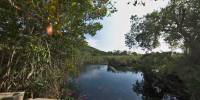

Manatees at Alligator Hole River
Canoe Valley, Clarendon Parish, Jamaica
March 18, 2006, 2:27pm, EDT

Loading panorama viewer ...
Configuring ...
© 2006 Katy Flanagan, All Rights Reserved.
Caption
We are shooting panoramas, video and stills for a web site we are producing for the Jamaica Protected Areas Trust. We happened to be in Jamaica during the Spring Equinox and while taking a break from work, we spent several hours at the Manatee observation site at Alligator Hole River, hoping to catch a glimpse of the endangered Manatees impounded there.We were lucky to see two Manatees and one American Crocodile and several species of birds during our visit. One of the wetland birds, a Common Moorhen, was quite agitated when the crocodile swam past and we recorded its distress cry along with the calls of White-winged Doves. An HD video of a Manatee feeding at the river is available on our Mountain Visions web site.
In an attempt to manage and study the declining population of West Indian Manatees (Trichechus manatus) in Jamaica, in the 1980s, a restricted captive area was developed at the Alligator Hole River in the parish of Clarendon on the south central side of Jamaica. Four different female Manatees that were captured by fishermen were released in the enclosure. The border for the Manatees is an iron fence separating the river from the ocean.
Three of the Manatees still survive but they have almost completely consumed the aquatic vegetation they depend on for food. Consequently, they are now being fed a supply of seagrass that is brought from another river system nearby. Officials have decided against trying to catch a male Manatee to allow for mating because the food supply is not adequate.
It is rumored that officials are planning to release the three Manatees to the wild. They would be fitted with satellite tags and radio transmitters for tracking and monitoring to see if they will find a mating herd and eventually breed.
Additional sources of information about Manatees in Jamaica can be found at;
Natural History Society of Jamaica and the Three Manatees http://jamaicanmanatee.freeservers.com/pages/natura.htm
National Environment and Planning Agency – West Indian Manatee http://www.nrca.org/yourenv/biodiversity/Species/manatee.htm
Regional Management Plan for the West Indian Manatee, Trichechus manatus http://www.cep.unep.org/pubs/Techreports/tr35en/ct35nsja.htm
Status of Semi-Captive Manatees in Jamaica - PDF file report written in 2003 http://www.suagm.edu/umet/red/Mig03LAJAM.pdf
Manatees face rough waters around the globe - http://www.sirenian.org/LERMAN.html
Location
Lat: 17° 51' 59.7" N
Long: 78° 24' 37.5" W
Elevation: 64 Feet
Precision is: Unknown / Undeclared.
Equipment
Nikon D100 digital SLR, 17mm 3.5 lens, f11 at 1/125 - Kaidan QuickPan Spherical system. Produced with Realviz Stitcher 5.1.0, Photoshop CS, and Cubic Converter 2.1.
 Tap or click the zoom icon in the bottom right corner of the picture to switch between in-page and fullscreen view