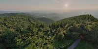

1000m Above the City
Schauinsland, Freiburg, Southwest corner of Germany
June 18 and 21, 2008 both 21:00 local time

Loading panorama viewer ...
Configuring ...
© 2008 Erik Krause, All Rights Reserved.
Caption
The Schauinsland is the local mountain of Freiburg. The summit lies just inside the city borders making Freiburg the city with the highest elevation difference in germany: more than 1000m from the center to the summit. And the tower on the summit raises the mountain's height over 1300m...Many people suffer from vertigo if they are in elevated places. Some even get vertigo from tilting down a spherical panorama taken high above the ground, like f.e. Welcome to Verdon
Vertigo, that is if you are unsure which way is up and which down. Well, since there was no high cliff at hand around solstice I tried to simulate the feeling. Perhaps you get some vertigo if you tilt the panorama up or down...
You can find the source panoramas on http://pano.erik-krause.de/sonnwend
Location
Lat: 47° 54' 43.11" N
Long: 7° 53' 54.93" E
Elevation: 1302
Precision is: High. Pinpoints the exact spot.
Equipment
Shot with Zenitar 16mm on 35mm Fuji Reala analog film, scanned with a coolscan LS40, stitched with PTGui Pro 8b4, enblend, photoshop
Behind the scene : how this panorama was made
I shot this panorama twice, once on june 18 and once on june 21. The weather was hazy the first time but the forecast was uncertain, hence I decide to jump at the chance. Saturday was much better, hence I went up once more. Featureless blue sky this time. Previously I played with vertically compressed and mirrored panoramas effectively giving two "little planet" versions at zenith and nadir. I placed the wednesday "little planet" in the sky region of the second panorama and let enblend do a seamless blending.
There was a second event I had to visit this evening: the solstice fire at the Freiburg vivarium Mundenhof. A huge pile of wood collected the whole year was burnt there and people where running and dancing around. An elevating experience as well and a very difficult subject to shoot due to ever changing brightness of the flames...
 Tap or click the zoom icon in the bottom right corner of the picture to switch between in-page and fullscreen view