

Loading panorama viewer ...
Configuring ...
© 2008 Randy Kosek, All Rights Reserved.
Caption
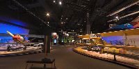
Only eleven years after the Wright brothers first successful flight, flying machines transformed warfare. These beautiful World War I fighter planes are on exhibit at the Boeing Museum of Flight, in Seattle.
You can see more of my images here; http://www.flickr.com/photos/akameus/sets/72157600305317333/
Equipment
Canon EOS 5D Camera,
Canon 15mm Fisheye Lens,
360Precision Adjuste Panoramic Head,
Bogen Tripod with Self-Levelling HeadSoftware: RAW Shooter Pro Premium, PT Gui 7.0, Adobe Photoshop CS2, Pano2QTVR
 Tap or click the zoom icon in the bottom right corner of the picture to switch between in-page and fullscreen view