

Loading panorama viewer ...
Configuring ...
© 2008 Markus Krueger,
Some Rights Reserved.

Caption
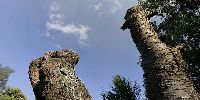
I elevated my tripod to it's maximum height and I took a standard stepladder to position my camera to take a picture of a dead tree in the garden.
A nice "Baumpilz" (in German .. maybe Bracket fungus is a correct translation .. at least the only one I found) is growing on the tree. I must admit that I was a bit disapointed because a few days before this WWP "Elevation" event I enjoyed a really impressive elevation that took me up to the topmost point of a monument close to my hometown: http://begemanns-mietlift.de/aktuell-hermann.php?pid=3 I erased myself, the guy is the operator.
However, this tree is dead for shure and dead in general is the most elevated place to get to – at least some people believe this. I elevated my Canon and myself to capture the most elevated state of beeing of our old cherry tree. Someone had to do this.
If you liked the panorama from the other URL, here are some more panorama movies. taken at the same place at different points of elevation. Enjoy.
Best Regards Markus
Location
Lat: 51° 58' 41.21" N
Long: 8° 47' 32.75" E
Elevation: 210cm
Precision is: Medium. Nearby, but not to the last decimal.
Equipment
Canon 5d, 15mm Sigma
 Tap or click the zoom icon in the bottom right corner of the picture to switch between in-page and fullscreen view