
Forgotten in the Forest
500m NE of Parks, Arizona, USA on Old Route 66
March 23, 2012, 19:30 zulu (12:30 local)

Loading panorama viewer ...
Configuring ...
© 2012 David Schaubert, All Rights Reserved.
Caption
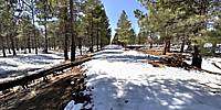
This is a secluded spot along the 1930s Route 66 in the Kaibab National Forest.At one time this was the main East-West route for vehicle traffic in the Southwest United States. Now abandoned, this section of Route 66 now has been re-purposed as a recreational hiking, riding, & bicycle path through the National Forest.
While it appears secluded, the sound in the area shows it is still part of a main transportation corridor with the normal forest sounds mixing with the dull roar of vehicles passing on the interstate and the horns and squeals of the railroad. Nearby are the remains of the 1857 Beale Wagon Road, the abandoned 1920s Route 66 alignment, the still-used 1940s Route 66 alignment, Interstate 40, and the mainline Burlington-Northern-Sante Fe Railroad line.
A link to more photos and panoramas in the area can be found here.
Location
Lat: 35° 15' 36.43" N
Long: 112° 57' 4.74" W
Elevation: 2175
Precision is: High. Pinpoints the exact spot.
Equipment
Canon XTi (400D) DSLR, Sigma 8mm f3.5 fisheye lens, Velbon D-580 Tripod, Nodal Ninja 3 (NN3) Pano Head, Apple MacPro Dual/Quad 2.8GHz XEON, PTGui Pro 9.1.3, Photoshop CS5 Extended, CubicConverter 2.2.1
 Tap or click the zoom icon in the bottom right corner of the picture to switch between in-page and fullscreen view