

Loading panorama viewer ...
Configuring ...
© 2012 Andy Savage,
Some Rights Reserved.

Caption
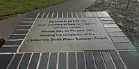
Mercian Way opened to traffic at 1:30 pm on March 16th, 2011, and connected the new Stafford Street roundabout with the Burton Road roundabout and Lara Croft Way, which was opened in July, 2010.In my 360 view I am standing in front of a commemorative plaque celebrating the opening of this new road. Here you can also see the combined pedestrian and cycle path.
Mercian Way officially opened on June 9th , 2011. Norman Baker, Under Secretary for the Department of Transport, unveiled the plaque among a crowd of Soldiers, members of the public, Mayor of Derby Councillor Les Allen and representatives from Derby City Council.
Mercian Way, which connects Burton Road roundabout with the Stafford Street roundabout, was the final piece of the £36.2 million Connecting Derby plan.
Maps, Photographs and Videos of Derby Inner Ring Road :
Map of the new Derby Inner Ring Road:
Lara Croft Way and Mercian Way on Derby Inner Ring Road.
Note that Google Maps and Google Streetview do not show this new road as it was built after Google surveyed the area.
360 View of the connecting road to Mercian Way.
Lara Croft Way 360 degree view.
Photographs of Mercian Way before it opened.
Videos of Derby Inner Ring Road before and after Mercian Way.
Derby Inner Ring Road in 2009.
Derby Inner Ring Road in July 2010.
A complete drive around Derby Inner Ring Road in April 2011.
A Time-lapse drive around Derby Inner Ring Road in April 2011.
Equipment
Nikon D70 DSLR fitted with a Nikkor 10.5mm lens on a Nodal Ninja head. Stitched with PTGui, converted to cube faces in Pano2VR, base of cube edited in PaintShop Pro X3 and equirectangular image finished in Pano2VR
 Tap or click the zoom icon in the bottom right corner of the picture to switch between in-page and fullscreen view