
Bird's-eye View of the Canary Islands
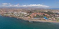
Gran Canaria, Canary Islands, Spain
April 16, 2011

Loading panorama viewer ...
Configuring ...
© 2011 Bernd Dohrmann, All Rights Reserved.
Caption
Air photo shooting above the island of Gran Canaria, which belongs to the Canary Islands.
Location
Lat: 27° 44' 6.59" N
Long: 16° 37' 9.49" W
Elevation: ca. 600 feet
Precision is: Unknown / Undeclared.
Equipment
Hardware:
Canon 600D - Sigma 8mm f/3.5 - self-made Nodal lens ring (German only, Google English translation) - monopod
Software:
Adobe Camera Raw 6.5 - Photoshop CS5 - PTGui 8.3 - Pano2VR
 Tap or click the zoom icon in the bottom right corner of the picture to switch between in-page and fullscreen view