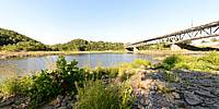

Gill - Montague Bridge
Turners Falls, Massachusetts, USA
Augiust 12, 2011, 4:35 pm

Loading panorama viewer ...
Configuring ...
© 2011 William M. Delabarre, All Rights Reserved.
Caption
Information on the Gill - Montague Bridge.
Location
USA-Canada / USA-Massachusetts
Lat: 42° 36' 41.21" N
Long: 73° 34' 15.02" W
Elevation: 133
Precision is: High. Pinpoints the exact spot.
Equipment
Nikon D7000 with Nikkor 10.5mm lens
 Tap or click the zoom icon in the bottom right corner of the picture to switch between in-page and fullscreen view