

Loading panorama viewer ...
Configuring ...
© 2008 Piotr Popik, All Rights Reserved.
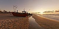
Location
Lat: 54° 16' 7.68" N
Long: 16° 4' 55.92" E
Elevation: 0
Precision is: High. Pinpoints the exact spot.
Equipment
The panorama was taken with Peleng MC f 3.5/8 mm lens (set at f 8, ~ 1.5 m) on Canon EOS 20D camera, (set at: 1/180, 1/500, 1/60s (normal, underexposed, overexposed); ISO 200). The panorama was stitched with 5 images (4 around plus zenith) using Professor’s Helmut Dersch Panorama Tools (PTGui 4.1 graphical interface). Autopano and Enblend, as well as Gimp's ability to create Text Circle Logo were all of great help.
I used 8 bit source images. Each of the 5 source images were produced from 3 images (underexposed, normal and overexposed) by enfuse. This was to produce much better looking images, thanks to Erik Krause :)
Equi-rectangular image was converted to QT with registered version 1.6.2 of Pano2QTVR pro.
 Tap or click the zoom icon in the bottom right corner of the picture to switch between in-page and fullscreen view