

Loading panorama viewer ...
Configuring ...
© 2013 George Row, All Rights Reserved.
Caption
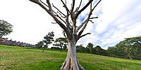
This dead tree stands in the middle of a green in Brooke Park in Derry. The park occupies a steeply sloping site with views over Derry city centre. It was named after the Brooke family who owned an estate, just outside Derry called "Brookhill".
James Brooke, who died in 1865, and his sister Margaret, who died in 1884, each left money in trust which was to be spent: " ... to secure an area of land to be used for recreation by the citizens of Derry."
Between them they left a total of over £10,000, (equivalent to a few million pounds in today's money). It was used to design the Park and lay it out with trees, shrubs and a fish pond. Brooke Park opened in 1901.
It was later bought by the City with the help of money donated by the "Honourable Irish Society". Derry City Council has administered the Park to the present day.
This tree probably grew here for over a hundred years before it died.
As a child I regularly visited Brooke Park, because the local Public Library used to be in a building known as Gwyn's Institute, within the Park grounds.
At that time the Park had many elaborate formal flower beds. My late father, who worked as a gardener elsewhere, took a keen professional interest in how they were maintained. I have an early memory of myself as an impatient 8-year-old waiting while he chatted to a gardener from the City Parks Department.
In recent years the Park has been on my route as I walk from home to the city centre.
According to a report in the local paper, the Derry Journal, the park is about to undergo a major refurbishment.
So this old tree that I pass every day will probably finally be felled.
All of this reminds me of my own mortality.
I have also made this and other Photographs of Derry available as:
Location
Lat: 55° 0' 2.48" N
Long: 8° 20' 49.3" W
Elevation: 200m
Precision is: High. Pinpoints the exact spot.
 Tap or click the zoom icon in the bottom right corner of the picture to switch between in-page and fullscreen view