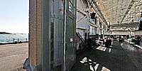

The Craneway Pavilion
Historic Ford Assembly Plant, Rosie the Riveter-World War II Homefront National Historic Park, Richmond, California, USA
September 23, 2011, 1 pm PDT
Loading panorama viewer ...
Configuring ...
© 2011 G. Donald Bain, All Rights Reserved.
Caption
For the last quarter century I have lived in Richmond, a city founded by the Santa Fe Railroad then transformed by the World War II shipyards. After a brief burst of importance and prosperity, it settled into post-war depression and built a reputation for ghetto poverty and gangland murder. But through it all there is discernable a heritage of cultural progress dating from the war years - the beginnings of worker child-care, Kaiser-Permanente (the first health maintenance organization - HMO), racially integrated public housing, and industrial jobs for minorities and women. This is celebrated in the national historic monument, a national park property with one of the longest names and one of the smallest areas - Rosie the Riveter - World War II Home Front National Historical Park. The monument consists of sites scattered through the former shipyard areas and adjacent neighborhoods.
The imposing 500,000 square foot (46,000 square meters) Ford Assembly Plant designed by Albert Kahn, was built in 1930. It is notable for its huge expanses of glass, both walls and ceilings. It has been renovated and is now used for modern light industry, specializing in solar photovoltaics, championed by Richmond's Green Party mayor.
At right angles to the main building is a craneway, designed for unloading materials from the wharf. It has been repurposed into the Craneway Pavilion and nows hosts trade shows and events, with lavish space and a great view over San Francisco Bay.
A former machine shop adjacent to the Craneway serves as museum and headquarters for the park service, and the former power plant has become the Boilerhouse Restaurant.
Location
Lat: 37° 54' 32" N
Long: 123° 22' 29" W
Elevation: 5 meters
Precision is: High. Pinpoints the exact spot.
Equipment
Photographed with a Canon 5D Mark II digital SLR with a 15mm Canon fisheye lens, on a Nodal Ninja VR mount, Really Right Stuff ballhead, and Gitzo carbon-fiber tripod. Stitched with PTGui Pro 9.0.4 on a MacBook Air, retouched with Photoshop CS3.
 Tap or click the zoom icon in the bottom right corner of the picture to switch between in-page and fullscreen view