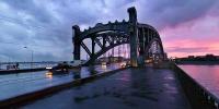

Bolsheokhtinsky Bridge on the Neva River
Saint-Petersburg, Russia
September 20, 2006 , local time 20:13 (Summer Time, UTC +3). 7 minutes after sunset.

Loading panorama viewer ...
Configuring ...
© 2006 Andrew Varlamov, All Rights Reserved.
Caption
People came this place on the right bank of the Neva in early 1300s. But 7 centuries later the land remains the battlefield of human passions.In 1300 the Swedes chose the source of the Okhta river to construct a fortress Landskrona. They found the most effective and fast way of constructing fortifications - a continuous ditch between the Okhta and the Neva was dug through. As referred to the Sweden chronicles of Erik Dahlberg “there was a wall with eight towers and embrasures; the ditch was dug between two rivers, the whole army was behind”. The fortress stood there for a year only: in spring 1301 the Novgorod citizens headed by Grand Prince Andrey Alexandrovich wiped it off the map.
The fortress Nyenskans took place in the source of the Okhta river in 1611 and consisted of 500 people “to defend the whole Neva under the aegis of the Sweden crown”. Small town Nyen is situated near the fortress on the opposite bank of the Okhta. In 1638 queen Kristina ... gave Nyen a right to receive foreign vessels and send local vessels to the other cities to trade. In 1642 she awarded Nyen with full rights of the Sweden Kingdom. Port freedom of Nyen allowed to receive vessels from overseas and conduct domestic and international trade. From 1640 to 1645 Nyen hosted from 92 to 112 vessels. Most of them were Russian boats together with boats from Sweden and towns from the Northern Germany, Holland and England. (2 paragraphs are citied from website of museum “700 Years — Landskrona, Nevskoye Ustye, Nyenskans”)
On May 1, 1703, during the Ingrian campaign of the Great Northern War, the fortress of Nyenskans was taken by Peter the Great.
After the city of Saint-Petersburg was created and Peter and Paul Fortress was founded on Zayachy Island, Peter I ordered to demolish fortifications of fortress Nyenskans.
New people came to the Okhta only in 1715, when Powder plant was founded. In 1717-1718 by assignment of Peter I 15 windmills were built on the bank of the Neva near the Okhta, they were removed from the Strelka of Vasilievsky Island to release place for building of Academy of Sciences. In 1806 Navy Department accepted the land near mouth of the Okhta river to found new shipyard. In 1818 after visit of Nicholas I the Okhtinskaya shipyard received status of Admiralty.
First time the idea to build a bridge near the Okhta river was circulated in 1829, when Nicholas I approved the bridge as part of strategic city development plan.
After all in September 1, 1901 the city Duma organized international contest. There were total of 16 projects submitted including projects from France, Germany, Austria, Spain and USA. Also there were three projects submitted out of contest. In according to recommendations of expert commission municipal goverment acquired 4 designs, including one named "Freedom for navigation" from professor of Nikolaevskaya engineering academy G.G.Krivoshein and military engineer (architect) V.P.Apyshkov. Authors were invited to produce final draft in 6 months, 40000 roubles were allocated for this task. It was decided to forget about other 3 designs, although representatives of engineering and architectural communities paid attention to its technical solutions and excelent exteriors. They were design "7.6" by engineer S.P.Bobrovskiy and architect V.P.Apyshkov, design "Kronshtadt-Toulon" by French building society "Levallois-Perret" and design "Two anchors" by A.Schnell of Viena. A.Schnell was the first and only who proposed to use reinforced concrete for bridge construction. (Let me assume that name of Paris suburb "Levallois-Perret" was used to mask participation of famous engineer and architect Gustave Eiffel)
In spring of 1907, the passenger ship Arkhangelsk which transported people from the left bank of Neva to the right bank has sank. This tragic event set things in motion, and on September 24, 1907 the contract for building the bridge was signed. The ceremony of bridge founding took place on June 26, 1909 - exactly two hunrend years from the Battle of Poltava. Hence the bridge was named after the triumphator of that battle - Emperor Peter the Great Bridge. The bridge was open for traffic on October 26, 1911. (citied from wikipedia.org)
Total length of the bridge is equal to 339,2 meters. The central span of 42,6 meters between towers is split into 2 equal bascules, which can be raised to an angle of 73 degrees to allow ships to pass. Minimum time of raising equals to 30 seconds. Total weight of metallic constructions is 8920 tons. (More technical details - in article of Dmitriy Maiorov)
Bolsheokhtinsky Bridge differs from other bridges constructed in Saint-Petersburg at the time - Trinity Bridge, Liteyny Bridge and Nikolayevsky Bridge. This extraordinary apperance permits the Bolsheokhtinsky Bridge to play a part of Tower Bridge in movie "Treasures of Agra" based on novel "The Sign of Four"" written by Sir Arthur Conan Doyle (film director is Igor Maslennikov, 1983)
It is part in the story of bridge where I become silent to give place press-cuttings. They will tell You about plans of transforming old plants on the right bank of the Neva into modern Gazprom-city crowned with 300-meter tower. It will be another story - story about transportation of strategic investor from Moscow into Saint-Petersburg.
On November 15, 2005 Saint-Petersburg Governor Valentina Matvienko and Chairman of the Executive Board of Gazprom Alexey Miller attended the presentation of international contest for the best architectural design of the Gazprom-City Business Center (News of JSC Gazprom).
The project of building a business and administrative centre at Malaya Okhta in Saint-Petersburg is aimed at erecting a complex of buildings with a dominating skyscraper business center (Press Release of JSC Gazprom Neft).
On April 17, 2006 St. Petersburg Vice Governor Alexander Vakhmistrov told reporters that Gazprom is finalizing negotiations to buy out Petrozavod plant (4.2 hectares) and intends to acquire Shturmanskie Pribory plant (4.5 hectares) and Okhtinskaya hotel (0.4 hectares). All three enterprises will widen the area of the business center, which Gazprom is constructing in St. Petersburg. (Kommersant Moscow)
In a letter to Governor Valentina Matviyenko released Thursday (July 6, 2006), the St. Petersburg Union of Architects said the tower will destroy the unique harmony of the city’s skyline and might result in St. Petersburg’s exclusion from the UNESCO list of world heritage sites.
“The low skyline makes the verticals of St. Petersburg especially magnificent… the conservation of inimitable silhouettes of its spires and domes is of great importance to town planning and spiritual importance,” reads the letter from the St. Petersburg Union of Architects.
“A 300-meter tower, more than twice as high as the Peter and Paul Cathedral and three times higher than St. Isaac’s and Smolny Cathedral, visible from all the main locations of the historical city center (even from Vasilievsky Island)…will bring the irreparable damage to the fragile skyline of the city as it will make all its verticals look almost toy-like,” the document continues.
The architects said the world already has the “depressing example” of London, where the Tower of London and historic cathedrals are now lost among skyscrapers, and Rome where the dome of St. Peter’s Basilica is no longer the city’s focus (Evgenia Ivanova in The St. Petersburg Times)(Explicit mistake of author - Architects wrote about St.Paul Cathedral).
Saint Petersburg, August 23, 2006. A meeting on the issue of realization of a major project on constructing a business and administrative centre in Saint Petersburg was held today in the Saint Petersburg Gazprom Neft office at Galernaya Street.
Saint Petersburg Governor Valentina Matvienko, Chairman of the Executive Board of Gazprom Alexey Miller, Gazprom Neft President Alexander Ryazanov, Gazprom Neft Invest General Director Nikolay Tanayev, representatives of the Government of Saint Petersburg as well as heads of six architectural companies – Herzog & de Meuron architekten (Switzerland), Ateliers Jean Nouvel (France), Studio Daniel Libeskind (Germany), Massimilliano Fuksas Architetto (Italy), UK RMJM (Great Britain) and Office of Metropolitan Architects (Netherlands) having won in the preliminary architectural tender participated in the meeting. Alexey Miller and Alexander Ryazanov welcomed the heads of the world leading architectural companies.
…In late October the architectural companies shall present their drafts of the business and administrative centre, after which the public hearings where the presented drafts will be discussed with the representatives of the municipal public organizations are to be held in the middle of November. (Press Release of JSC Gazprom Neft)
Are You interested in? Be online, keyword is "Gazprom-city".
External links
P.E.Sorokin "Predecessors of Petersburg. Landskrona - Nevskoye Ustye - NyenskansNyenschanz". Article on the website of the St.Petersburg Diocese gazette (in Russian)
The Neva river: Bridges. Postcards from Russian National Library. 1900-1917
Panoramic view of Bolsheokhtensky Bridge, looking from Smolny Cathedral - panorama shooted by Vladimir Shirokov in 2005
Location
Lat: 59° 56' 33.12" N
Long: 30° 24' 16.2" E
Elevation: 10
Precision is: High. Pinpoints the exact spot.
Equipment
Hardware: Camera Pentax *ist DS equipped by Pentax SMC P-DA Fish-Eye 10-17mm F3.5-4.5 ED (IF) lens, FalconEyes tripod with self-made L-shaped panoramic headSoftware: PTGui 6.0 by New House Internet Services B.V. (dated by September 13, 2006 - 2 weeks later version 6.0.2 was issued), MinGW version of PanoTools library 2.8.0 (dated by November 24, 2005) from Jim Watters' PanoTools site, Smartblend 1.2.2 by Michael Norel, Pano2QTVR version 0.9.0 by Thomas Rausher.
Caption in Russian (Перевод на русский язык) - Большеохтинский мост через Неву
Это место на правом берегу Невы было заселено людьми в начале 14 века. Но и 7 веков спустя оно остается ареной, вокруг которой кипят людские страсти.Именно устье реки Охты было выбрано в 1300 г. шведами для строительства крепости Ландскрона. Шведы выбрали наиболее быстрый и экономичный способ строительства укреплений: был прорыт сплошной ров между Охтой и Невой. Как свидетельствует шведская хроника Эрика Дальберга «Над тем рвом стояла стена с восемью башнями с бойницами; ров был вырыт между обеими реками, за ними стояло все войско». Но крепость простояла всего один год: весной 1301 г. новгородцы, под предводительством Великого князя Андрея Александровича спалили ее до основания.
Крепость Ниеншанц появилась в устье реки Охты в 1611 году и вмещала гарнизон из 500 человек «чтобы можно было защищать всю Неву под эгидой шведской короны». Неподалеку от крепости, на противоположном берегу Охты, расположился небольшой городок Ниен. В 1638 году – королева Кристина ... даровала Ниену стапельное право – разрешение принимать иностранные суда и отправлять свои корабли в другие города с торговыми целями, а 1642 году пожаловала Ниену полные городские права Шведского королевства.
Портовая свобода Ниена дала возможность принимать иностранные суда и вести внутреннюю и внешнюю торговлю. С 1640 по 1645 г.г. Ниен ежегодно посещали от 92 до 112 кораблей. Большинство из них были русские ладьи, а также суда из Швеции и ее Балтийских владений. Примерно пятую часть составляли корабли, приходившие из городов Северной Германии, Голландии и Англии. (3 абзаца цитируются с сайта музея «700 лет – Ландскрона, Невское устье, Ниеншанц»)
1 мая 1703 года во время Великой Северной войны, крепость Ниеншанц была взята войском Петра Первого.
После того, как был основан Санкт-Петербург, а на Заячьем острове была построена Петропавловская крепость, Петр I приказал разрушить укрепления крепости Ниеншанц.
Новые жители пришли снова на Охту лишь в 1715 году, когда был построен Пороховой завод. В 1717-1718 гг. по распоряжению Петра Великого, по берегу Невы, у устья Охты было поставлено около 15 ветряных мельниц. Они были перенесены сюда со Стрелки Васильевского острова, где освобождалось место для строительства Академии наук. В 1806 г. Морское ведомство приобрело земли на мысу в устье реки Охты, где впоследствии была создана новая верфь. В 1818 году после посещения Охтинской верфи Николаем I, ей был пожалован статус Адмиралтейства.
Впервые идея строительства моста у реки Охты возникла в 1829 году, когда Николай I утвердил перспективный план Петербурга. Наконец 1 сентября 1901 года Городская Дума объявила международный конкурс. На конкурс поступило 16 проектов, в том числе из Франции, Германии, Австрии, Испании и США. Три проекта были представлены вне конкурса. По рекомендациям экспертной комиссии, городскими властями были приобретены четыре проекта, среди которых был представленный вне конкурса проект под девизом "Свобода судоходству", принадлежавший инженеру Г. Г. Кривошеину и архитектору В. П. Апышкову. Авторам его предложили в шестимесячный срок составить окончательный проект, ассигновав для этого 40 тыс. рублей. О других проектах решили не вспоминать, несмотря на то, что инженерная и архитектурная общественность находила некоторые из них оригинальными по техническому решению и высоким внешним данным. К ним относились проекты под девизами: "7. 6" (авторы инженер С. П. Бобровский и архитектор В. П. Апышков), "Кронштадт - Тулон" французского строительного общества "Левале - Перрэ" и "Два якоря" (автор А. Шнелль из Вены). Среди участников конкурса Шнелль был первым и единственным автором, решившим переправу в железобетонных конструкциях. (Позвольте предположить, что имя парижского пригорода Левале - Перрэ скрывает участие всемирно известного Густава Эйфеля)
Весной 1907 года пароход "Архангельск", перевозивший пасажиров с левого берега Невы на правый, опрокинулся и затонул. 24 сентября 1907 года был заключён договор на строительство моста. Начало работ ускорила резолюция императора "Не затягивать строительства моста". 7 июля 1908 года был принят договор с заводом "Рудзский и К" на постройку моста к 7 июля 1911 года. Торжественная закладка его произошла в честь двухсотлетия Полтавской битвы 26 июня 1909 года. Поэтому мост и назвали в честь триумфатора этой битвы, именем императора Петра Великого. Для движения новый мост был открыт 26 октября 1911 года (цитириуется с сайта "Прогулки по Петербургу").
Общая длина моста составляет 339,2 метра. Центральный пролет между башнями шириной 42,6 метра разделен на два равных крыла, которые могут быть подняты до угла в 73 градуса для пропуска судов. Минимальное время раскрытия пролетов равно 30 секундам. Общая масса всех металлоконструкций составляет 8920 тонн (прочие технические детали раскрыты в статье Дмитрия Майорова).
Большеохтинский мост отличается от мостов, построенных в Петербурге в то время - Троицкого, Литейного и Николаевского. Такой необычный внешний вид позволил Большеохтинскому мосту сыграть роль Тауэрского моста в фильме "Сокровища Агры", поставленному по повести Артура Конан-Дойля "Знак четырех" (режиссер Игорь Масленников, 1983).
В этой части истории моста я умолкаю, чтобы уступить место газетным вырезкам. Они расскажут о планах преобразования старых заводов на правом берегу Невы в современный "Газпром-сити", увенчанный 300-метровой башней. Это будет другая история - история о приходе стратегического партнера из Москвы в Санкт-Петербург.
Минимальная площадь объекта должна составить 1 миллион квадратных метров – это здание высотой в 300 метров. Средства на строительство будут выделяться согласно целевой программе, рассчитанной на 2007 – 2016 годы, ежегодно из горбюджета будет выделяться по 200 миллионов долларов, а из средств «Сибнефти» - по 100 миллионов, - сообщил депутатам Михаил Осеевский. Комплекс разместится на территории примерно в 25 гектаров, рядом с гостиницей «Охта» (напротив, через Неву, располагается здание Смольного). Здесь, в частности, будут размещаться офисы «Сибнефти» и других компаний-налоговых доноров, перерегистрированных в Петербурге. Небольшой участок рядом с гостиницей «Охта» несколько лет назад был предоставлен компании «Газпром» для проведения проектно-изыскательских работ и строительства офиса. К этой территории будет присоединены примерно 10-12 гектаров участка «Петрозавода» и 10 гектаров, принадлежащих ранее заводу «Штурманские приборы». Здания этих двух заводов будут снесены. (За «Газпром-сити» губернатор ответит лично Александра Медведева, Фонтанка.Ру)
Петербургские архитекторы написали открытое письмо губернатору Валентине Матвиенко и спикеру Законодательного собрания Вадиму Тюльпанову, в котором выразили резкий протест против строительства в центре города 300-метровой башни комплекса «Газпром-сити». … Архитекторы назвали эти планы «настоящим преступлением перед будущими поколениями петербуржцев» и попросили губернатора пересмотреть условия конкурса на проектирование небоскреба. По их мнению, его появление нанесет «непоправимый ущерб» облику города
«Строительство 300-метровой башни более, чем в 2 раза превышающей шпиль колокольни Петропавловского собора, в 3 с лишним раза купол Исаакия и собора Смольного монастыря, видимой по существу ото всех основных мест исторического центра (даже с Васильевского острова!), с неизбежностью разрушит гармонию петербургских доминант, складывавшуюся столетиями», - говорится в письме архитекторов. (Архитекторам не нравится "Газпром-сити" Надежда Зайцева, Фонтанка.Ру)
Перед нами печальный пример Лондона, где Тауэр и старые храмы затерялись на фоне небоскребов, а купол собора св. Павла перестал быть общегородской доминантой.
… уместно напомнить, что наш город - объект Всемирного наследия ЮНЕСКО, предметами охраны которого являются, в частности, панорамы и виды, воспринимаемые с набережных Большой Невы, соотношение фоновой застройки с системой доминант (силуэт города), видовые точки, с которых наилучшим образом воспринимаются архитектурные доминанты. А ведь именно таковой является территория, на которой предполагается возведение небоскреба: она входит в зону 3 регулирования застройки по проекту Зон охраны культурного наследия центральных районов Санкт-Петербурга (границы утверждены Правительством Санкт-Петербурга 28 июня 2005 года). Для нее допускается «новое строительство в соответствии с …заключением историко-культурной экспертизы, определяющей возможную высоту застройки, обеспечивающей сохранение исторических панорам центра». Наконец, объект культурного наследия, включенный в Список всемирного наследия, каковым является Петербург, автоматически признается особо ценным объектом культурного наследия народов России (Федеральный закон «Об объектах культурного наследия…», ст.24).
Таким образом, принятое решение о проведении конкурса входит в глубокое противоречие с действующими правовыми нормами, ставит под вопрос сохранение Петербурга в Списке всемирного наследия. (Открытое письмо губернатору Санкт-Петербурга Фонтанка.Ру)
Санкт-Петербург, 23 августа 2006 года. Сегодня в офисе ОАО "Газпром нефть" в Санкт-Петербурге на Галерной улице состоялось совещание по вопросам реализации крупного проекта строительства административно-делового центра в Санкт-Петербурге.
В совещании приняли участие губернатор Санкт-Петербурга Валентина Матвиенко, председатель правления ОАО "Газпром" Алексей Миллер, президент ОАО "Газпром нефть" Александр Рязанов, генеральный директор ООО "Газпром нефть Инвест" Николай Танаев, представители правительства Петербурга, а также руководители шести архитектурных компаний, победивших в предварительном архитектурном конкурсе. Это компании Herzog & de Meuron architekten (Швейцария), Ateliers Jean Nouvel (Франция), Studio Daniel Libeskind (Германия), Massimilliano Fuksas Architetto (Италия), UK RMJM (Великобритания) и Office of Metropolitan Architects (Нидерланды). Алексей Миллер и Александр Рязанов выступили с приветственным словом руководителям ведущих мировых архитектурных компаний.
…В конце октября архитектурные компании предоставят эскизные проекты административно-делового центра, а в середине ноября в Санкт-Петербурге пройдут общественные слушания, на которых представленные проекты будут обсуждаться с представителями городских общественных организаций (Пресс-релиз «Газпром нефть»)
Заинтересовались? Оставайтесь на линии, ключевое слово - "Газпром-сити"
Полезные ссылки
П.Е.Сорокин "ПРЕДШЕСТВЕННИКИ ПЕТЕРБУРГА Ландскрона - Невское устье - Ниеншанц". Статья на сайте Санкт-Петербургской митрополии
Мосты через Неву. Открытки из Российской Национальной библиотеки. 1900-1917
Вид на Неву и мост Петра Великого (Большеохтинский) со звоницы Смольного собора - панорама Владимира Леонидовича Широкова, 2005
Behind the scene : how this panorama was made
I had got only 2 days for shooting, because weekend was busy to spend it with my family. In the morning of September 20 I picked up tripod and equipped camera leaving home. I didnt take umbrella relying on absence of rain.
Weather was suitable but not excelent, sky was closed by clouds, and I reached my workplace with dry shoes.
On lunchtime rain started. In the evening rain became shower. When I came to Bolsheokhtinsky bridge after workday,
shower was so hard that I was obliged to hide under bridge crossing the Okhta river (it shown on panorama as hill covered by lighting cars).19:28 (local time) - I mounted and adjusted tripod and shooted two series of shots. Parameters of camera were the next: Exposure mode Manual, sensitivity ISO 400, shutter speed 1/30 sec, aperture f/3.5, White Balance Cloudy. Suddenly small ship occured under bridge going to enter the Neva. View was non-interesting, Bolsheokhtinsky bridge was not shown completely. Wind was from the west and I suspected that clouds could go away.
19:40 - shower stopped and I was free to choose new position for shooting. I went along Petrozavod plant rising to bridge. Light rain continued and I waited some time hiding under roof near walls of plant. To save time I opened tripod legs and screw spirit level. Suddenly over the left bank of the Neva sky began to clean. Rain stopped completely and sky on the west became scarlet. Traffic along embankment was so dense that there was no time to choose position near the Neva. I waited while pair of cars turn to the bridge, crossed the corner and ran to bridge.
20:05 - I chose position which was the most suitable to shoot both the bridge and the road along embankment. I shooted two series of 8 shots (6 horizontal, 2 zenith, bottom shot is still my weak place). The second one was more successfull because sun lightened old plants by pink colors and dark figure of girl occured on the opposite side of the bridge. Parameters of camera were the next: Exposure mode Manual, sensitivity ISO 800, shutter speed 1/20 sec, aperture f/3.5, White Balance Cloudy. Focal length was 11 mm, I occasionally touched lens wheel. But next day PTGui Optimizer said me that quality of stitching was very good.
 Tap or click the zoom icon in the bottom right corner of the picture to switch between in-page and fullscreen view