

Loading panorama viewer ...
Configuring ...
© 2010 Jean Berthélémé, All Rights Reserved.
Caption
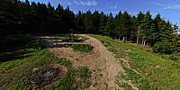
Fort Folly is not completely forgotten but the area is better known for the historical "Chapelle Ste-Anne de Beaumont" which is situated about a kilometre from this site. Fort Folly can be confused with Fort Folly First Nation Band, located in nearby Dorchester.Fort Folly is located at the confluence of the Petitcodiac and Memramcook rivers; it protrudes into Shepody Bay. The tidal flats visible in the distance are the result of the tides of the Bay of Fundy, perhaps the highest in the world. The Hopewell Rocks, a popular tourist attraction, is located within a few kilometres (as a bird flies).
There used to be some sort of lighthouse here, as corroborated by the remaining small triangular metallic structure and the junk-filled pit in the ground. According to my research, it was built in 1890, was 35 feet (10.6 m) high and could be seen as far away as 14 nautical miles.
Fort Folly can be reached by driving on a narrow country road that that runs from Memramcook to Beaumont, via Taylor Village. Expect a bumpy unpaved ride in some places; a 4x4 vehicle or hiking boots are recommended!
For more information see: Chapelle Beaumont or Fort Folly
Fort Folly n'est pas complètement oublié, mais la région est mieux connue pour le site historique Saint-Anne-de-Beaumont qui est situé à environ 1 kilomètre. Fort Folly peut aussi être confondu avec le “Fort Folly First Nation Band”, situé à Dorchester.
Fort Folly est situé au confluent des rivières Petitcodiac et Memramcook; c'est un cap qui s'avance dans la Baie de Shepody. L'attraction touristique populaire “Hopewell Rocks” est à quelques kilomètres d'ici (à vol d'oiseau).
Il y avait un phare ici autrefois, comme en témoigne une petite structure métalique et un trou rempli de détritus. D'après mes recherches, le phare, construit en 1890, avait 35 pieds (10,6 m) de hauteur et était visible jusqu'à 14 miles nautiques.
On peut se rendre à Fort Folly en empruntant un petit chemin étroit, en grande partie non-pavé, qui va de Memramcook à Beaumont en passant par Taylor Village. Le chemin peut être cahoteux; un véhicule tout-terrain ou des souliers de marche sont recommandés.
Pour plus d'information, visitez : Chapelle Beaumont or Fort Folly
Location
USA-Canada / Canada-New Brunswick
Lat: 45° 52' 8.4" N
Long: 65° 34' 39.6" W
Precision is: High. Pinpoints the exact spot.
Equipment
This 360-degree image was shot from a 14-foot pole on a DSLR camera. The lens used was an 8mm fisheye. The view is a full 360 x 180 degrees.
 Tap or click the zoom icon in the bottom right corner of the picture to switch between in-page and fullscreen view