
Isartalbahn – Remains of a Closed Railway Track
Grosshesselohe, Bavaria, Germany
June 26, 2010, 13:50 UTC (15:50 local time)

Loading panorama viewer ...
Configuring ...
© 2010 Carl von Einem, All Rights Reserved.
Caption
Between 1891 and 1964 a railway line connected several villages alongside the river valley of the Isar in the southern parts of Munich with the then outskirts of the city. Passengers and goods were transported over a distance of about 50 km (31 miles). It was privately built and run at first but later taken over by the German national railway system. The line is now defunct and only parts of it were reused by Munich's public transport network built for the 1972 Olympic summer games.Parts of the infrastructure are still in use - the former train station building in Großhesselohe these days serves as a restaurant with its own brewery, another building in Munich is used as a base for a rescue service. This latter building sometimes puzzles people driving on the road nearby: it really looks like a typical railway station made out of brick stone but there are no trains or tracks to be seen!
But some remains like overgrown steel rails in the bushes beside the street can still be discovered. If you follow this hidden path with a bicycle you will also find the former train depot, which is still waiting for better times, somewhere in an area that looks like an urban jungle.
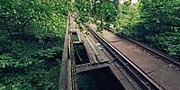
Parts of the old railway tracks were converted into a nice walking and cycling trail several years ago. At the southern end of the new cycleway the road turns into a path with coarse gravel - the old railbed. Time to dismount and carefully push the bike over the sharp edged gravel so we can find out where this path ends. What I found was this old railway bridge you can see in my panorama. It was fun to rediscover it and it sure is fun to have a closer look at the satellite view that is linked below. The typical straight path of railway tracks makes it relatively easy to follow these old trails and find some forgotten places.
Location
Lat: 48° 4' 28.72" N
Long: 11° 31' 55.45" E
Elevation: 553 m (1814 ft)
Precision is: High. Pinpoints the exact spot.
Equipment
- camera:
Zeiss-Ikon SW 35mm format rangefinder camera
lens:
Voigtländer 12mm Heliar (1/8 sec., f8)
film:
Kodak Ektar 100 ISO color negative film
- panohead:
Novoflex mounted on a monopod
- 16-bit scans:
Nikon LS-4000 ED w/SA-30 film roll adapter (SilverFast Ai 6.6 scan software)
- stitching software:
Hugin 2010.1.0-38ed0587798b built by Harry van der Wolf for Mac OS X (Thanks!)
- additional software:
Photoshop CS
 Tap or click the zoom icon in the bottom right corner of the picture to switch between in-page and fullscreen view