
Rideau Canal at Jones Falls
Jones Falls on the Rideau Canal, Ontario, Canada
3:30 PM EST

Loading panorama viewer ...
Configuring ...
© 2004 Jim Watters,
Some Rights Reserved.

Caption
The Rideau Canal joins Kingston and Ottawa Ontario with a series of scenic lakes, rivers, and canals. Conceived after the War of 1812, in case America tries to invade Canada again, to be a war-time supply route to Kingston and the Great Lakes from Montreal. Construction started in 1826 by Colonel John By, to change an old Indian canoe portage route into one of the greatest engineering feats of the 19th century. Completed in 1832 with a total of 49 locks joining 202 kilometers. It is now the oldest continuously operated canal in North America, working today much as they did then. The Rideau Canal is a National Historic Site of Canada and Canadian Heritage site it is slated to be a World heritage site in a few years.
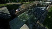
Jones Falls Locks 39 to 42 with a total lift of 17.8m ( 58.4 ft.) The site also consist of an arch dam 350 feet in length and 62 feet high built of sandstone blocks 6' by 3' by 2' placed on end. Over 200 men, including 40 masons, worked on the dam and locks. When built in 1830 it was the highest arch dam in North America. The sandstone was replaced with concrete pre-cast blocks in the early 20th century. A small power generator has also been added to the dam.
Visible in this pan is the Turning Basin at the top, locks 40, 41, & 42, and Whitefish Lake at the bottom. Lock 39 is up around the corner joining the Turning Basin to Sand Lake. The dam holds back Sand Lake from its original channel and is behind the trees on the other side of the locks. The lock masters are at work allowing a ship to make its way up stream.
For more information see the Rideau Canal Waterway.
More views of Rideau Canal by Jim Watters.
Location
Lat: 44° 32' 45" N
Long: 77° 15' 2" W
Precision is: Medium. Nearby, but not to the last decimal.
Equipment
Nikon 995 with Fisheye(FC-E8) / Custom L bracket on 14 foot pole / 6 images 20 deg down 4 images 20 deg up plus 1 down / PTGui with PanoramaTools & Photoshop
 Tap or click the zoom icon in the bottom right corner of the picture to switch between in-page and fullscreen view