
Rising Above My House (for the first time)
Issaquah, Washington, USA
March 29th, 2021 - 1:00 PM PDT

© 2021 Bryant Arnett, All Rights Reserved.
This image represents my passion for creating panoramic images RISING from the ashes of broken cameras and crashed drones as my new camera literally RISES above the Earth for the very first time.
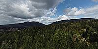
We are 300 feet above my house near the foot of Tiger Mountain near Issaquah, Washington, a small town to the East of Seattle, in a neighborhood called Mirrormont.
It's been 16 years since my first participation in the World Wide Panorama event. So much has happened and the technology has advanced SO far. I remember how my first submission took me about 40 hours of aligning and editing and processing and ripping my hair out to try to get it right. I didn't use a pano-head when I took the pictures, so the parallax correction was CRAZY and I had to figure it all out manually. Not to mention two completely different exposure zones (Pre-HDR!). It was my "Marketplace" contribution, and it inspired me to keep going, and to keep trying to get it right. I went on to submit 15 images.
I built and flew drones for many years, but could never get the images I wanted for a good aerial perspective. Recently, thanks to my friend Joey, I now fly a DJI Mini2. It is easily the most advanced piece of technology I have ever possessed. The first few days saw rain but finally, a couple of days ago, the sky cleared, and I could send it up for a test pano image. It sent chills through me as I watched it quickly spin around the full rotation, snapping the required images for a panorama. When it was done, and it dropped back to Earth and delivered the files, I quickly realized I needed to upgrade my copy of PTgui. The last version I registered was 9, and I easily updated to the most recent version, dropped all of the images into it, exported the equirectangular and uploaded it here. Total time spent: about 10 minutes. That's it. I made no other edits or adjustments. That's how far we have come.
I obviously need to figure out how to fill zenith and also use RAW images and manual settings and probably a whole bunch of other things to maximize my future images. This was the very first panoramic image I took with my new Mini2 drone, and I expect my next contribution to be much improved. Rise!
This image was created by sending up my DJI Mini2 drone 300 feet above my house, telling it to make a panoramic series of photos using automatic settings, and then dropping those photos into PTgui, clicking "Align Images" then "Create Panorama" and then uploading the exported equirectangular image to this website. Easiest thing in the world.
 Tap or click the zoom icon in the bottom right corner of the picture to switch between in-page and fullscreen view