

Loading panorama viewer ...
Configuring ...
© 2012 Michele Zanin, All Rights Reserved.
Caption
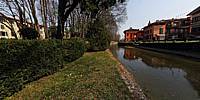
Il Naviglio della Martesana è lungo 40 chilometri, attraversa numerosi centri abitati ed è affiancato da una stradina che negli ultimi anni è sempre più usata dai cicloamatori.
Negli anni '90 l'idea di far rivivere il naviglio della Martesana si è concretizzata con l'inaugurazione di una pista ciclopedonale lungo il tratto che, partendo da Cassina de' Pomm raggiunge Gorla, Precotto, Crescenzago.
Oggi che il naviglio ha superato i 500 anni di vita la pista ciclabile che lo costeggia da Milano raggiunge Cassano d'Adda, collegandosi alla pista ciclabile del fiume Adda.
Lungo la pista ciclabile, che porta da Milano all'Adda si scopre un paesaggio inaspettato fatto di cascine, ville sontuose, ponticelli, antichi casolari e borghi, giardini, orti e anatre con pulcini ed anche gabbiani cornacchie e colombe.
Il percorso è pianeggiante e costeggia costantemente il corso d'acqua, è a tratti all'ombra ma prevalentemente esposto al sole.
Recentemente è stato asfaltato anche il segmento da Vimodrone a Cernusco sul Naviglio (era l'unico rimasto ancora sterrato).
http://it.wikipedia.org/wiki/Naviglio_della_Martesana
English text from Wikipedia:
The Naviglio della Martesana is a canal in the Lombardy region, Northern Italy. Running from the Adda river, in the vicinity of Trezzo sull'Adda, to Milan, it was also known as Naviglio Piccolo. It is part of the system of navigli of the Milan area.
Approximately 38 kilometres long, with a substantial section covered over or infilled, its width varies between 9 and 18 metres, while the depth is between one and three metres.
Originally named Naviglio Piccolo, it subsequently changed to Martesana from the name of the county across which it runs.
Along the way it crosses the boundaries of the villages of Trezzo sull'Adda, Vaprio d'Adda, Cassano d'Adda, Inzago, Bellinzago Lombardo, Gessate, Gorgonzola, Bussero, Cassina de' Pecchi, Cernusco sul Naviglio and Vimodrone, and gives the name Martesana to all this area. The canal enters Milan alongside Via Padova until Cassina de' Pomm: at the junction with Via Melchiorre Gioia it disappears underground following the route of Via Melchiorre Gioia itself southwards. In the past it would have passed through the Fossa dell'Incoronata and the Laghetto di San Marco to connect with the Fossa Interna (or Inner Ring). Today, after merging with the river Seveso, the underground course becomes the Cavo Redefossi in the vicinity of Porta Nuova, runs under the cerchia dei bastioni to Porta Romana, follows Corso Lodi and Via Emilia, finally ending up in the River Lambro.
Equipment
Canon EOS 7D - Sigma 8mm f/3.5 - Manfrotto 190B - 360Precision Atome Head - PTGui Pro
 Tap or click the zoom icon in the bottom right corner of the picture to switch between in-page and fullscreen view