
Path to the Past
Upper Bonnechere River area, Ontario, Canada
March 21, 2012, 2:30 pm EST

Loading panorama viewer ...
Configuring ...
© 2012 Alex Makienko, All Rights Reserved.
Caption
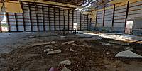
Forest trails and paths sometimes bring you to strange places...This abandoned airbase at Killaloe/Bonnechere airfield, hidden deep in the Ontario forests near the Round Lake, Ontario, reminds us of the Cold War times. Built in 1952, it ceased operations in 1988, it was a home base for interceptors during the East-West confrontations. Almost nothing has left here, however the runway is still in moderate condition and from time to time small private aircraft land here and local teenagers use the runway for car and bike races. The Government has tried to stop this by installing trespass warning signs but this has had little effect.
Thanks to Don Fabian for his kind permission to get in and to my friend Dave Lute who is my good partner for years in travels and hiking into deep into the Canadian wilderness.
Equipment
Nikon D80, Nikkor 10.5mm f/2.8, stitching software: PanoLab3D
 Tap or click the zoom icon in the bottom right corner of the picture to switch between in-page and fullscreen view