

Loading panorama viewer ...
Configuring ...
© 2006 Yasuhiro Fujimoto, All Rights Reserved.
Caption
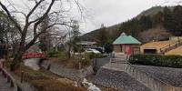
The lowest central watershed in Japan is within this park. This central watershed is flatland of 1250 meters, the lowest place is 95 meters above sea level.
Rain that falls here: When it flows to north, rain flows in the Sea of Japan, When it flows to south, rain flows in the Seto Inland Sea.
A watershed that is located in plain section is also biologically precious existence also on geology.
Location
Lat: 35° 9' 2.38" N
Long: 135° 4' 21.25" E
Elevation: 95m
Precision is: High. Pinpoints the exact spot.
Equipment
Hardware: Fuji S3Pro, Nikkor 10.5mm, Manfrotto/Bogen 303SPH, MDeVe aluminum video tripod.
Software: Kekus Digital PTMac and Click Here Design CubicConverter.
 Tap or click the zoom icon in the bottom right corner of the picture to switch between in-page and fullscreen view