
Prius Part 1
Fort Worth, Texas USA
December 17, 2016 0947 am (UTC -6) Central Texas Time

© 2016 Dave Albright,
Some Rights Reserved.

2017 Prius Hybrid (Electric / Gasoline (Petrol) vehicle. The manufacturer’s goal is design and build the safest car on the road.
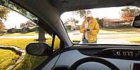
HUD (Heads up Display) You can see the white symbol markings on my yellow jacket. This is the heads up display as displayed on the inside surface of the glass windshield (wind screen). It displays the vehicle current speed and electric motor / gasoline engine usage.
The lower console displays real time digital speed, the current day’s driving distance and current miles/gallon.
The vehicle is equipped with forward radar cruise control that senses the distance between this car and the car in front of you. The system alerts you to when you are following to close for safe stopping. If you ignore the alert sounds it will automatically apply the brakes to avoid a collision.
This vehicle has 10 external proximity sensors that alert you to when the objects are too close. 4 of the sensors alert the driver to approaching vehicles that are in the drivers left and right blind rear spots. The rear end sensors also alerts to approaching human other vehicles cross traffic. Yes, if you do not manually stop, it will take over and automatically stop.
Of course there are the standard GPS mapping features and cellphone hands free Bluetooth connectivity.
All of the internal lighting and external lights are low consumption LED.
Fuel efficiency high/low range:
40 miles/gallon or 14 Litres/100km
65 miles/gallon or 23 Litres/100km
ALL these features make the Prius a safe vehicle and one of the best vehicles. These features are standard available in the 2016 and 2017 models.
Lat: 32° 39' 36.76" N
Long: 98° 23' 16.54" W
Elevation: 787 feet above mean sea level
Precision is: High. Pinpoints the exact spot.
Dell AI1 64bit Intel i7 27" Touch Screen monitor, Theta-S, Photoshop CS6 (non Cloud) Adobe Camera Raw 9.1, Targus Grypton TG-GT80G-101 15" (37mm) Flexible Tripod, PTgui Pro 64 bit 10.0.15, Pano2vr Pro version 5.1b 64 bit Image Converter.
 Tap or click the zoom icon in the bottom right corner of the picture to switch between in-page and fullscreen view