

Loading panorama viewer ...
Configuring ...
© 2010 Miguel Sepúlveda, All Rights Reserved.
Caption
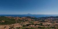
The Strait of Gibraltar, a strategic and necessary step,
is a great crossroads of the world. The landscape with mountains on both sides, is a natural step for the wind. Strong currents, due to differences in salinity of the Mediterranean make this area a point of constant instability.Whales, dolphins, tuna and many other marine species and the migration routes of birds from Europe to Africa pass through this point, door of the Mediterranean Sea.
For man, the strait has been the bridge between two continents. The first inhabitants of Europe crossed here, Phoenicians, Carthaginians, Romans, Arabs took this area as a strategic point for their conquests. A hot zone during World War II. A marine traffic of more than 85,000 boats per year, of all types and in all directions pass through here.
In recent years used illegal immigration as a way to narrow gateway to Europe. It is estimated that about 5,000 immigrants a year try to cross these dangerous waters. Many die in the attempt.
El estrecho de Gibraltar, punto estratégico y paso obligado, es una de las mayores encrucijadas del mundo. La orografía, con montañas en ambas orillas canalizan los vientos en ambos sentidos, atraves 14,4 kilómetros en el punto más angosto. Fuertes corrientes marinas, debido a las diferencias de salinidad de las aguas del Mediterráneo, hacen de esta zona un punto de inestabilidad constante.
Ballenas, Delfines, Atunes y otras muchas especies marinas cruzan por este paso natural y puerta del Mediterráneo. Todas las rutas migratorias de aves procedentes del norte de Europa, pasando por la península Ibérica con destino África confluyen en este punto.
Para el hombre, el estrecho ha sido puente entre dos continentes. Los primeros pobladores de Europa cruzaron por aquí, civilizaciones antiguas: Fenicios, Cartagineses, Romanos, Árabes tomaron esta zona como punto estratégico para sus conquistas.
Un tráfico marino de más de 85.000 buques por año, de todo tipo y en todas direcciones pasan por aquí.
En los últimos años la inmigración clandestina utiliza el estrecho como vía de entrada a Europa. Se estima que unos 5,000 inmigrantes al año intentan cruzar estas peligrosas aguas. Muchos pierden la vida en el intento.
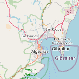
Location
Lat: 36° 3' 9.54" N
Long: 6° 33' 59.82" W
Elevation: 278 m
Precision is: Unknown / Undeclared.


Equipment
Camera Olympus, ZUIKO 8mm fisheye lens Manfrotto Panoramic Head 303SPH
 Tap or click the zoom icon in the bottom right corner of the picture to switch between in-page and fullscreen view