
Cancun Airport Tower 2
Cancun International Airport Tower, Cancun, Quintana Roo, Mexico
September 17, 2011, 12:15 pm (-6 GMT)

Loading panorama viewer ...
Configuring ...
© 2011 Pat Albright, All Rights Reserved.
Caption
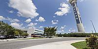
In 2009, Cancun’s International Airport became Mexico’s first to have the capacity to handle simultaneous takeoffs and landings on two runways. The control tower, more than 315 feet tall, is the 18th tallest in the world, allowing improved efficiency in runway-use time assigned to aircraft, is beneficial to both passengers and the 150 domestic and international airlines that use the airport.Cancun International Airport now has 3 terminals. Terminal 1 is the first terminal at the airport and is used for private aircraft, charters and freight. Terminal 2 is for Mexico's domestic and some international flights. Terminal 3 is for international flights only.
Our Travel Host in Mexico
Nodal Ninja Ultimate R1 and R10
Pano2VR
PTGui
Krystal Hotel, Hotel Zone 9.5km Cancun, Mexico.
Nodal Ninja Ultimate R1 and R10
Pano2VR
PTGui
Krystal Hotel, Hotel Zone 9.5km Cancun, Mexico.
Location
Lat: 21° 2' 27.43" N
Long: 87° 53' 20.59" W
Elevation: Elev 24 feet (8 meters) elevation above Mean Sea Level
Precision is: High. Pinpoints the exact spot.
Equipment
Canon 500D, Sigma 8mm f/3.5, Monopod, Fanotec Nodal Ninja Ultimate R1 Ring Mount Pano Head, 4 Raw images +5 deg tilt up, Adobe Raw Converter 6, Adobe Photoshop CS5, PTGui 9.1 beta 2 Pro, Pano2VR 3.1.0 Panoramic Image Converter (Rev 1777/4.7.2 August 11, 2011).
 Tap or click the zoom icon in the bottom right corner of the picture to switch between in-page and fullscreen view