

Loading panorama viewer ...
Configuring ...
© 2011 aleksandar janicijevic,
Some Rights Reserved.

Caption
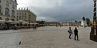
On our drive back to Paris, France, we decided to spend the night in Nancy. We didn't know much about this city, it was selected just for its location. Nancy is the capital of the French province of Lorraine, former Duchy of Lorraine, and it turned out to be what it is most famous for.Until the death of Duke Stanislas in 1766 it was an independent Duchy. Place Stanislas is one of the very real squares [actually the only other one, that I am aware of, is Campidoglio in Rome], designed by one person [Emmanuel Héré de Corny] and where all of the buildings were built at once between 1752 and 1755. A bronze statue of Louis XV stood in the middle of the square until it was removed during the Revolution. In 1831 a bronze statue of Duke Stanisław Leszczynski (Stanislas in French) was placed in the middle of the square, since then known as the "Place Stanislas".
The Hôtel de Ville, now centered on this magnificent square, and the Hôtel du Gouvernement, the seat of city government and the seat of Ducal government face one another as complements through a series of rational, symmetrical, yet varied urban spaces unequaled in Europe at the time. Few other buildings around the square where today opera and the museum of applied arts are located are completing this urban space. Together with the connected Place de la Carrière and Place d'Alliance, Place Stanislas has been on the list of UNESCO World Heritage Sites since 1983.
A massive restoration, inspired by the original 18th Century plans, was finished and inaugurated in May 2005 to mark its 250th anniversary. History well preserved, appreciated and used in today's world, what else we can expect for heritage urban spaces.
phenomenal travel blog: http://lets-get-lost.com
more squares all over the world - http://urbansquares.com
Location
Lat: 46° 41' 35.97" N
Long: 6° 10' 59.89" E
Elevation: 205
Precision is: High. Pinpoints the exact spot.
Equipment
Panasonic LX3, handheld, PTGui, Photoshop, Apple iMac
 Tap or click the zoom icon in the bottom right corner of the picture to switch between in-page and fullscreen view