
Small Philadelphia Side Street
Philadelphia, Pennsylvania, USA
September 24, 2006 - 21:23 UTC (17:23 local time)

Loading panorama viewer ...
Configuring ...
© 2006 Yischon Liaw,
Some Rights Reserved.

Caption
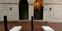
The major streets in Center City Philadelphia follow a strict grid laid out by William Penn and Thomas Holme in 1687. Over the following century, landowners began parcelling out the land within the grid, forming small streets and alleyways behind the buildings that fronted the major streets. (This can be easily seen on the maps linked below.)Belgium block (carved granite blocks) paving was the main paving method in the 19th century, covering both major and small streets in the city. Although the major streets are now mostly covered with asphalt (much more compatible with air-filled rubber tires), many small streets still retain the paving from almost two centuries ago. Cars (and trash trucks!) do travel down these streets so often residents will put up bollards in the sidewalks, providing some protection to their houses.
The two blocks of marble on the sidewalk in front of the doorways are also transportation related. They often have an address number, a family name, or initials engraved on them. The blocks are carriage steps, used to climb up into or down from a horse-drawn carriage.
 Tap or click the zoom icon in the bottom right corner of the picture to switch between in-page and fullscreen view