

Loading panorama viewer ...
Configuring ...
© 2004 Éric Lerch, All Rights Reserved.
Caption
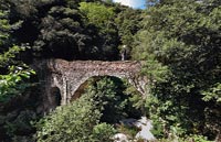
Just large enough to let the passage of a man or a horse, this little bridge resisted to the tempestuous torrent. The roman part of the bridge is the one with the rounded arch, then the original drawbridge was substituted by the larger arch (foreground) at XIVth century. On the other side, behind the modern bridge, is the spanish border at about 2 hours of walk.All the region (Roussillon) was successively crossed over by hords of Wisigoths, Templars, Sarrasins, brigands, smugglers or Spanish soldiers, depending of the day...
It's now a nice and peacefull place for hiking and fishing delicious trouts.
Equipment
Nikon CP5000 (28 mm) for about thirty images, shot 'à la romaine' (with a plumb line). Stitcher and Photoshop.
 Tap or click the zoom icon in the bottom right corner of the picture to switch between in-page and fullscreen view