
5in1: The Montreal's St-Lambert Lock System and other bridges on the St Lawrence river.
Montreal, Quebec, Canada

Loading panorama viewer ...
Configuring ...
© 2004 Yann Leroy, All Rights Reserved.
Caption
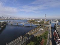
The St-Lambert lock system is one of the giant locks of the St-Lawrence Seaway. The St-Lawrence Seaway connects the Atlantic Ocean to the Great Lakes. The waterway was a project jointly run by the United States of America and Canada. Its construction lasted from 1954 to 1959, and more than 22,000 people worked on the construction of the St. Lawrence Seaway. It was officially opened for navigation on the 26th of June 1959 when Queen Elizabeth II and U.S. President Dwight D. Eisenhower traveled through the St. Lambert lock on the Royal Yacht Britannia.About the panorama itself:
In the background, you can distinguish the Champlain bridge (1960) and the Jacques Cartier bridge (1932). On the island, you can also recognize the F1 racing circuit of Montreal. In the foreground, facing Montreal's skyscrapers, the Victoria Bridge (1859) crosses the St-Lawrence River and is split in 2 parts to cross the lock in order to allow an uninterrupted way of circulation for both trains and cars. The picture of the panorama was taken from the top of the South gate bridge, near the big wheels (around 4 meters diameter) that operate the cables that lift the mobile part of the bridge. The North gate bridge facing the ship underneath completes the twin bridge system and is shown with the railway lifted up.
Don't forget to take a close look at the entire project's webpage at http://www.candau.com/wwp200409 where you will find some special effects and an animation of the whole lock system.
Equipment
 Tap or click the zoom icon in the bottom right corner of the picture to switch between in-page and fullscreen view