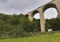

Le Viaduc des Fauvettes
Bures sur Yvette - Essonne - France
17:30 GMT +1, 21 September 2004

Loading panorama viewer ...
Configuring ...
© 2004 Christophe Peus, All Rights Reserved.
Caption
built in1907, bombarded in 1944, rebuilt in 2004.Old railway between Chartres and Paris
Big spot for climbing
Equipment
Hardware: Canon D60, 15mm sigma
 Tap or click the zoom icon in the bottom right corner of the picture to switch between in-page and fullscreen view