
Where Families Meet
Ottawa, Ontario Canada
Saturday, June 25, 2011, about 8:30 pm EST

Loading panorama viewer ...
Configuring ...
© 2011 Robert Agnel, All Rights Reserved.
Caption
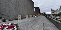
There were (at least) two weddings happening in the National Arts Centre, this pano was shot on the east deck. Directly across the Rideau Canal is the new Ottawa Convention Centre, panning right is Confederation Park where the Ottawa Jazz Festival featured KD Lang and the Siss Boom Bang Band. Back around behind me past the two little girls running back to the wedding reception are the green castle-like towers of the Chateau Laurier Hotel in front of which is the old train station, on the right is the Westin Hotel. These are all places with a connection to families.
Location
Lat: 45° 25' 24.38" N
Long: 76° 42' 33.13" W
Elevation: 69 m
Precision is: High. Pinpoints the exact spot.
Equipment
Nikon D90 with a Nikkor 10.5mm lens, Stitcher Unlimited, Pano2VR, handheld zenith and nadir
 Tap or click the zoom icon in the bottom right corner of the picture to switch between in-page and fullscreen view