

Loading panorama viewer ...
Configuring ...
© 2010 Michel Thoby, All Rights Reserved.
Caption
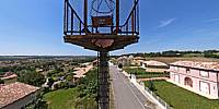
The first commercial airline service from Toulouse to Barcelona started during the harsh winter of 1918. Postal Air service was subsequently extended to Rabat in Morocco and was inaugurated in March 1919.After WW I, the French Air Navigation Service (SNAE) had taken over the management of aviation infrastructure. It soon appeared that the development of commercial aviation was linked to the need to operate day and night. It was not yet a question of instrument flying at night though. In 1923 the SNAE developed a network of aeronautical Light Beacons (Aviation Lanterns) intended to constitute an "illuminated map of air routes" for the night traffic on major routes. By 1932 there were almost 140 such lanterns. Every light beacon emitted a light combination that featured color points corresponding to a Morse Code letter identifying the location. For example, Baziege had the letter G. Each beacon was manually switched-on just before the passage of a plane.
The system was abandoned in 1940 but some of its infrastructure was spared from destruction during the war. Two of them are still standing today on the air route Paris-Bordeaux-Toulouse-Narbonne-Perpignan. The first one is shown in this panorama and the second is at Montferrand (Aude).
If their aesthetic value is questionable, they have some historical value as the prestigious "South Atlantic Aeropostale Line" and their heroic pilots are famous: Antoine de Saint-Exupery, writer and aviator, is known the world over as the author of "The Little Prince".
In order to contribute to the WWP event, I decided to shoot a panorama up on the hill north of the small town of Baziege. A recent housing project has grown and many new houses now surround the lantern, but there is no one in charge of switching the light on or off upon receipt of a telegram to do so. No Aeropostale plane is expected to fly over here after taking off at Toulouse-Montaudran(*), 19km from Baziege...
I am told that the last man in charge of maintaining and operating the light beacon was a miller. His windmill was next to this "electric aviation lantern." Its wing were folded but the ruined tower of the windmill is still visible at Monteserre, a few footsteps from the old platform on top of its pole of rotten concrete.
While shooting the photos, I was thrilled to see (and hear) an Airbus A380, the newest, biggest and heaviest airliner that was test-flying right over the scene. Hence the presence of the huge airplane in this panorama: this strange coincidence illustrates the historical anachronism of this obviously forgotten place!
NOTE(*)
The famous Toulouse-Montaudran airfield is now disused since 2004. http://michel.thoby.free.fr/Baziege/Montaudran_piste&Pancarte.html
This panorama was shot in 2008.
Condominiums and other buildings as well as a large scientific aeronautical and space complex are presently being built on the runway...
Location
Lat: 43° 27' 22.93" N
Long: 1° 37' 20.44" E
Elevation: 200 meters
Precision is: Unknown / Undeclared.
Equipment
Canon EOS 5DMk2Tokina 10-17mm @ 12mm
Manfrotto 269HDBU pole (7.2 m) augmented with a 3.2 m extension
The camera was about 10.7 m from the ground and fixed on a home-made panorama bracket that is 40 cm tall.
 Tap or click the zoom icon in the bottom right corner of the picture to switch between in-page and fullscreen view