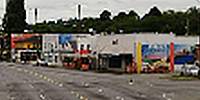

South Park Bridge
South Park, Washington, USA
June 27, 2010, 19:17 UTC (12:17 local)

Loading panorama viewer ...
Configuring ...
© 2010 Douglas L. Urner,
Some Rights Reserved.

Caption
Seattle's historic South Park Drawbridge between the South Park neighborhood on the south end and the Georgetown neighborhood and the city of Tukwilla on the north end, carried approximately 20,000 vehicles a day across the Duwamish Waterway. The bridge was completed in 1931 and had long been recognized as unsafe by the state. Despite the bridge being a vital link for the community, money was not budgeted for repair or replacement of the bridge and it was closed (by leaving it open) on the 30th of June, 2010. South Park is an ethnically diverse neighborhood of moderate means surrounded by industrial areas. On the north shore of the Duwamish is one of the original Boeing plants. The area has suffered heavy air, soil, and water pollution.
Location
Lat: 47° 31' 40.58" N
Long: 123° 19' 52.06" W
Precision is: High. Pinpoints the exact spot.
Equipment
Nikon D700 with 24-70mm f/2.8 at 24mm / Panorama head from Manfrotto and RRS components / Stitched with RealViz Stitcher 5.1 on a PowerMac G5 running OS X 10.5.8.
 Tap or click the zoom icon in the bottom right corner of the picture to switch between in-page and fullscreen view