
The Redundant Church
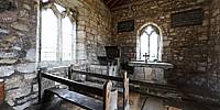
St. Mary's Church, Lead, North Yorkshire, England
June 27, 2010, 12:30 pm

Loading panorama viewer ...
Configuring ...
© 2010 Eva Pitt,
Some Rights Reserved.

Caption
St. Mary's Church, Lead, dates from the 14th Century. This tiny, simple church stands alone, somewhat sad, melancholy and desolate, in the middle of a field. It has never served as a parish church and has been declared redundant.The church has been rescued from neglect in 1931 and is now cared for by The Churches Conservation Trust. It remains unaltered, is still consecrated and accessible to the public, but because of its lonely location is somewhat forgotten.
The most poignant memory for this church is its proximity to the battlefield of Towton. Here on March 29, 1461, Palm Sunday, Edward Duke of York engaged Henry VI of Lancaster and there was fighting from dawn to dusk in a severe blizzard. In this, "the longest and the bloodiest battle ever fought on English soil," Henry was defeated. It is thought that about ten thousand men died and many more were wounded. The Battle of Towton brought the Wars of the Roses to an end.
St Mary's church remains as the only building that saw the warriors pass by, but the surrounding fields are remembered as Bloody Meadow and Red Fields.
Information from The Churches Conservation Trust brochure and website.
Equipment
Canon EOS 450D, Sigma 10-20mm, Nodal Ninja 3, PTGui for Mac, Photoshop CS4, CubicConverter
 Tap or click the zoom icon in the bottom right corner of the picture to switch between in-page and fullscreen view