
Sunday Morning Under The "L"
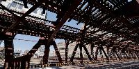
Wells Street Bridge, Chicago, Illinois, USA
June 22nd, 2008 • 11:15am Local • 1615 UTC

Loading panorama viewer ...
Configuring ...
© 2008 Victor Zaveduk,
Some Rights Reserved.

Caption
To a Chicagoan, the word "elevation" brings to mind the elevated trains of Chicago's public transit system. The "L" circles the downtown area - the "Chicago Loop" - and connects the central city with neighborhoods to the north, south and west. Here the "L" crosses the Chicago river heading north above Wells Street on a double layered bridge creating at least three levels of elevation; trains above, cars below, and boats below that!But from this spot, on a bridge spanning the Chicago River, several other variations on "elevation", both current and historical, are evident. The two ends of the bridge "rise" in the middle, as necessary, to allow river traffic to pass. Chicago is the home of this type of twin-leaf bascule bridge design. There are eighteen drawbridges in the downtown area and dozens more throughout the city. The control room for this bridge is up in the structure adjacent to the bridge, overlooking the street. Although the bridge crosses the river at street level, true "ground level" is as much as eight feet below as the streets were raised artificially in the late 1850's to accommodate the installation of new sewers. Even the elevation of the river itself has changed. At the turn of the twentieth century, Chicago completed the Sanitary & Ship Canal, reversing the flow of the river and connecting Lake Michigan shipping with the Des Plaines, and ultimately the Mississippi, rivers. The water level in the Chicago River used to be higher than, and flowed towards, Lake Michigan. Now the level of the river is lower than the lake and flows away. And of course, construction is visible everywhere in the city as new buildings "rise" along the skyline. Construction on new skyscrapers overlooking the river is visible to the east, adding to the "elevation" of the city.
Equipment
This HDR panorama was created by taking bracketed images, using a Nikon D80 camera equipped with a Nikor 10.5mm wide-angle lens, mounted on a "Nodal-Ninja 3" spherical bracket atop a Manfrotto Tripod. Enfuse was used to combine the images which were then stitched using PTGuiPro 8.0, postprocessed with Photoshop, and compiled into QuickTimeVR format using Pano2VR.
 Tap or click the zoom icon in the bottom right corner of the picture to switch between in-page and fullscreen view