

Loading panorama viewer ...
Configuring ...
© 2008 Kazuyoshi Yura,
Some Rights Reserved.

Caption
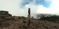
To take a picture, my wife and I climbed Mt.Kurodake(1,984 meters = 6,509 feet). Sometimes the trails to the top were still covered with snow.
And after two hours, we arrived at the top of the mountain, but it was cloudy. We could not look around the mountains below to our regret.
Location
Lat: 43° 41' 54.63" N
Long: 142° 55' 12.09" E
Elevation: 1,984 meters = 6,509 feet
Precision is: Unknown / Undeclared.
Equipment
Nikon coolpix, monopod, PtGui, PANO2QTVR
 Tap or click the zoom icon in the bottom right corner of the picture to switch between in-page and fullscreen view