
Elevation
On the road to Vens, Alpes Maritimes, France
June 21, 2008 - 16:09 local time

Loading panorama viewer ...
Configuring ...
© 2008 Gregory Moine,
Some Rights Reserved.

Caption
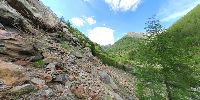
I shot this pano during a road trip from Nice to the small village of Bousiéyas, in the Southern French Alps.
I stopped on route du Col de la Bonnette near Vens, and climbed up 80 meters to take the shots. Going up was okay, going down was a bit scary with 50-degree angle slopes and unsettled rocks to deal with.
The view shows a very small part of the beautiful Mercantour National Park. If you pan down, you may see the Tinée river.
- This panorama is brought to you by Greg Moine, a Boston Real Estate Photographer
- More panos by me (on this site)
- More France 360s:
- Le Meridien Hotel in Nice (Sea View)
- Rene Socca Famous Nice Restaurant
Equipment
Gear:
- Nikon D70s
- 10.5mm Nikkor Fisheye lens
- 360Precision Absolute PanoHead
- Manfrotto 755B tripod
Software:
- PtGui
- Pano2Qtvr
- Photoshop CS3
 Tap or click the zoom icon in the bottom right corner of the picture to switch between in-page and fullscreen view