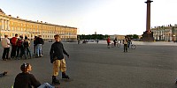

Roller Skaters awaiting Friday Night Skate
Palace Square, Saint-Petersburg, Russia
June, 15, 2007 - 19:15 UTC (23:15 local time) - 8 minutes to sunset and white night

Loading panorama viewer ...
Configuring ...
© 2007 Andrew Varlamov, All Rights Reserved.
Caption
Friday Night Skate in Saint-Petersburg became regular event in 2002. Skating season lasts all summer long, till October. Skaters meet at Palace Square at 11pm and start skating at 11:30pm.
Route of FNS for Saint-Petersburg is published on web page http://www.inline.spb.ru/anons/pin.shtml.
Links
- Munich Inline Skating Paramedics panorama by Markus Matern
- In 2004-2006 I was participant of student community at St-Petersburg Faculty of photojournalism. Panorama shooted in May 31, 2007 shows new generation of the community.
Acknowledgments
I wish to express my gratitude to people who proofread Spanish and English captions for my panorama (in alphabetical order): Olivier Auverlau, Alfredo Mora Izaguirre, Ken Stuart, Pau Valiente MoralLocation
Lat: 59° 56' 20.4" N
Long: 30° 19' 3.72" E
Elevation: 1.5
Precision is: High. Pinpoints the exact spot.
Equipment
Hardware:
Camera Pentax *ist DS, Pentax SMC P-DA Fish-Eye 10-17mm F3.5-4.5 ED (IF) lens, Manfrotto 055CLB tripod, Manfrotto 303SPH multi-row pan head
Software: PTGui 6.0.3 by New House Internet Services B.V. (dated by 10 october 2006), MinGW version of PanoTools library 2.8.0 (dated by November 24, 2005) from Jim Watters' PanoTools site, Pano2QTVR version 1.5.2 pro flash by Thomas Rausher.
Caption in Russian (ru) - Роллеры в ожидании ПИН (пятничного ночного заезда)
Пятничные инлайн ночные заезды роллеров в Санкт-Петербурге стали регулярными в 2002 году. Ночные заезды проводятся все лето до октября. Сбор - на Дворцовой площади в 23:00. Заезд начинается в 23:30.Маршруты ПИН публикуются на сайте http://www.inline.spb.ru.
Caption in Spanish (es) - Patinadores en línea esperando el "Friday Night Skate"
El "Friday Night Skate" en San Petersburgose celebra regularmente desde 2002. La temporada de rutas nocturnas es durante todo el verano hasta Octubre. El punto de encuentro es en la Plaza del Palacio a las 23h, la salida de los patinadores es a las 23:30h.La ruta del FNS de San Petersburgo se publica en la web: http://www.inline.spb.ru/anons/pin.shtml.
Behind the scene : how this panorama was made
Weather conditions were suitable for early Spring :
sky without clouds, strong west wind, air temperature was equal to +10°C. Wind was so strong that I spent some time at home solving problem which tripod to use - old heavy Falcon Eyes or new light Manfrotto 055 CLB.I made 4 series of shots from 2 different positions. Shooting parameters: 6 shots around, 1 shot of zenith, 1 hand-held shot of nadir, ISO 400, shutter speed = 1/125sec, aperture = F3.5, focal length = 10mm, white balance = Daylight, quality = RAW, recorded pixels = 3008x2008.
 Tap or click the zoom icon in the bottom right corner of the picture to switch between in-page and fullscreen view