

Loading panorama viewer ...
Configuring ...
© 2005 Adam Robinski, All Rights Reserved.
Caption
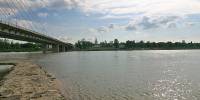
The Vistula river (Wisła in Polish) is the longest Polish river. Originating in mountains in the south of the country, it flows through the major cities, such as Cracow, the capital Warsaw, Toruń and Gdańsk. It finishes its journey in the Baltic sea, after 1047.5 kilometres. It is often called 'a wild river in the heart of Europe', its middle and lower sections are considered to be one of Europe's most exceptional areas of natural and landscape value. Photographed in Warsaw, under the Świętokrzyski Bridge, the Vistula remains wild and unspoilt in the middle of a 2 million people city.
See the Vistula's upper section near Cracow - Piotr Popik's entry.
Equipment
EOS 300D, Zenitar 16mm, PTGui
 Tap or click the zoom icon in the bottom right corner of the picture to switch between in-page and fullscreen view