WWP Home arrow right This Event arrow right Indices: Alphabetical | Regional | Thumbnail | Map previousPrevious | Nextnext
event title
Pacific
portrait Pat Rooney
Kewalo Basin Park
Honolulu Shore, Hawaii, USA
mini manual

This should be a panorama image.

If you can read this, something went wrong.
We support these player technologies:

With ... you can view ...
Apple QuicktimeVR
(part of Quicktime)
all contributions
Adobe Flash Player 10.1 or newer most (not all, some contributions are QTVR-only due to historical reasons)
Javascript + HTML5 / WebGL many, but depends on photographer's choice of file upload (newer event = more likely to work) and your device's capabilities. You may experience slow playback, distorted images or unexpected browser quitting if there is only limited memory/GPU power available.
[?]
Copyright © 2005 Pat Rooney, All Rights Reserved
Previous panorama: Adam RobinskifullscreenA-Z Regions ThumbnlsShow in MapNext panorama: Uwe 'hammernocker' Roßberg

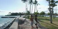
The Honolulu shoreline attracts plenty of surfers when the waves are right. A deep channel next to a coral reef makes for good swells when conditions are right. There are several surfers on the waves, but you can only make out the ones coming back in.

Looking toward the ocean and to the left you can see the buildings of Waikiki and Leahi, or Diamond Head. To the right you can see the point from which many surfers get in the water - the very tip of Kewalo Basin Park. It starts a channel that ships follow to the basin to moor.

Location Map Geographic Coordinates:
Latitude: 21° 17' 27.52" N
Longitude: 157° 51' 31.5" W
Elevation: 3m
Precision is: High. Pinpoints the exact spot.

arrow Show at MultiMap.com [what is MultiMap?]
arrow Show at Google Maps [what is Google Maps?]
arrow Show in Google Earth* [what is Google Earth?]
* requires Google Earth
installed on your computer

Date/Time:
20 June 2005, 4 pm


text
WWP Home arrow right This Event arrow right Indices: Alphabetical | Regional | Thumbnail | Map previousPrevious | Nextnext