
Slieve Binnian — Limits of Visibility
Mourne Mountains, County Down, Northern Ireland, UK
Saturday, March 19, 2011, 17:00 GMT

Loading panorama viewer ...
Configuring ...
© 2011 George Row, All Rights Reserved.
Caption
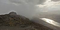
This panorama was shot on the summit of Slieve Binnian mountain. At 747 metres this is the third–highest mountain in Northern Ireland. Below Slieve Binnian to the west is the Silent Valley Reservoir.The name comes from the Irish: Sliabh Binneáin (meaning "mountain of the little peaks") which refers to the rocky tors around the top of the mountain. This rugged crest of rocky tors makes Slieve Binnian easy to identify in views of the Mourne Mountains.
The Mourne Wall–a dry–stone structure 2m tall and 1m across–crosses over Slieve Binnian. The Wall, which took 18 years (at the start of the 20th Century) to complete, winds across the Mourne mountains for 35 KM. It marks the limits of the catchment area for the Silent Valley reservoir.
The reservoir supplies water to the population of County Down and to most of Belfast.
My original intention for this event was to shoot a panorama depicting the Mourne Wall, showing as it does the limits of the water catchment area. However as we reached the summit the mists came in and that view could no longer be seen.
Instead this panorama depicts the “limits of visibility;&rdquo on the mountain top. It was shot on one of the pinnacle tors. It opens with a view of other hill–walkers on an adjacent tor.
As the panorama starts to rotate the view passes up the Silent Valley Reservoir and into the mist. Had the mist not closed in, a vista taking in the rest of the Mourne Mountains would have come into view at this point and when the rotation completed we would have been returning to a view, possibly as far as, the Wicklow Mountains, on a clear day.
Other panoramas of County Down
Prints of Slieve Binnian are available at RedBubble, where it is available as a: greeting card , framed print or as a canvas-print
Prints of Slieve Binnian are available at RedBubble, where it is available as a: greeting card , framed print or as a canvas-print
Location
Lat: 54° 8' 31.29" N
Long: 6° 59' 48.54" W
Elevation: 747m
Precision is: High. Pinpoints the exact spot.
Equipment
The source images were taken with a Canon EOS 5D, Zenitar 16mm fisheye f/2.8 lens. The camera was mounted on a Kaiden Kiwi panorama adapter on a Manfrotto 190XDB tripod.Horizontal photographs were taken at 60° angles and also two ground shots and a sky shot. Each "shot" consisted of three bracketed exposures from +2 to -2 stops.
A total of 27 separate images were combined using Hugin in order to achieve this High Dynamic Range-type result.
 Tap or click the zoom icon in the bottom right corner of the picture to switch between in-page and fullscreen view