
The Sacramento River at its Flood Limit
The Sacramento River from Tower Bridge, Sacramento, California, USA
March 25, 2011 10:30 am PDT

Loading panorama viewer ...
Configuring ...
© 2011 G. Donald Bain, All Rights Reserved.
Caption
A week of heavy rain in mid-March pushed most reservoirs and rivers in California to near capacity. The Sacramento River, largest in the state and critical to the state's economy, rose to its flood control limit. This was countered by opening the floodgates and diverting part of the river's flow through the Yolo Bypass, averting urban flooding and easing pressure on the levees in the delta downstream.The official flood level, 27.5 feet, is measured at the I Street Bridge, seen upstream from here. Built in 1911 it is a combination road and railroad bridge, still in use by passenger trains. The original transcontinental railroad ended at Sacramento and passengers continued by paddlewheel steamer to San Francisco.
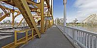
Tower Bridge crosses the Sacramento River on the south edge of Old Sacramento, the historic heart of "river city". This massive lift bridge, built in 1935, was a notable link in the historic Lincoln Highway, the first highway to span the entire country from New York to San Francico. This is also a continuation of the Capitol Mall - the state capitol building is visible in the distance.
The riverfront Gold Rush town of Sacramento suffered from numerous floods, and was even rebuilt one story higher than the original streets in an effort to stay dry. But the real threat came with the advent of freeways, and the area was almost demolished to make way for Interstate 5. Thankfully the freeway was moved east a few blocks and Old Sacramento survived to become a state historic park and a popular recreation area. It is home to numerous historic buildings, the California State Railroad Museum, and the Delta King paddlewheeler floating hotel.
More panoramas of the Old Sacramento riverfront, and a view of the Yolo Bypass filled with floodwaters diverted from the river, can be found on my Virtual Guidebooks website.
Location
Lat: 38° 34' 50.47" N
Long: 122° 31' 30.23" W
Elevation: 5 meters
Precision is: High. Pinpoints the exact spot.
Equipment
Photographed with a Canon 5D Mark II digital SLR with a 15mm Canon fisheye lens, on a Nodal Ninja VR mount, Really Right Stuff ballhead, and Gitzo carbon-fiber tripod. Stitched with PTGui Pro 9.0.3 on a Macintosh Intel Core 2 Duo iMac, retouched with Photoshop CS3.
 Tap or click the zoom icon in the bottom right corner of the picture to switch between in-page and fullscreen view