

Loading panorama viewer ...
Configuring ...
© 2010 Nurcan Azaz, All Rights Reserved.
Caption
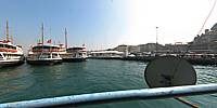
This is a panorama of the Galata Bridge which crosses the Golden Horn (Halic) in Istanbul, Turkey. The bridge was built for the first time by Sultan Abdülmecid in 1845. It connects Karaköy and Eminönü. The last bridge restoration was in December 1994.The new bridge is 488.65 meters long and 42 meters high, and it has an platform that opens for ships. A rail system crosses the bridge along with several lanes for automobiles.
The bridge represents one of the traditional icons of Istanbul. It is a bridge that connects two cultures to each other: Old and new Istanbul. Under the bridge there are many fish restaurants, cafes, and pubs. Over the bridge many people come for fishing everyday. People sit on the Galata Bridge and enjoy their fish on the plate while they watch fishhooks flying and they gaze at the beautiful Golden Horn. At night it is more crowded and colorful with lights of the city all around.
Equipment
Photographed as handheld shot with my Canon A640 and Nikon FC-E9 fisheye lens, edited in Adobe Photoshop 7.0, stitched in PTGui.
 Tap or click the zoom icon in the bottom right corner of the picture to switch between in-page and fullscreen view