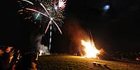
WWP Home arrow right This Event arrow right Indices: Alphabetical | Regional | Thumbnail | Map previousPrevious | Nextnext
event title
Europe
portrait Joakim Löber
Food for the Flames
Klein-Breitenbach, Odenwald, Hessen, Germany
mini manual

This should be a panorama image.

If you can read this, something went wrong.
We support these player technologies:

With ... you can view ...
Apple QuicktimeVR
(part of Quicktime)
all contributions
Adobe Flash Player 10.1 or newer most (not all, some contributions are QTVR-only due to historical reasons)
Javascript + HTML5 / WebGL many, but depends on photographer's choice of file upload (newer event = more likely to work) and your device's capabilities. You may experience slow playback, distorted images or unexpected browser quitting if there is only limited memory/GPU power available.
[?]
Copyright © 2010 Joakim Löber, All Rights Reserved
Kugelblick.de
Previous panorama: Jann LipkafullscreenA-Z Regions ThumbnlsShow in MapNext panorama: Bo Lorentzen

Lärmfeuer = light a fire in order to raise an alarm. First mentioned in local history 400 years ago.

A little bit more information (only in German):

http://de.wikipedia.org/wiki/L%C3%A4rmfeuer

http://www.laermfeuer.org

Location Map Geographic Coordinates:
Latitude: 49° 36' 33" N
Longitude: 8° 44' 5" E
Elevation: 210 m
Precision is: Medium. Nearby, but not to the last decimal.

arrow Show at MultiMap.com [what is MultiMap?]
arrow Show at Google Maps [what is Google Maps?]
arrow Show in Google Earth* [what is Google Earth?]
* requires Google Earth
installed on your computer

Date/Time:
March 27, 2010, 21:03 CET

Equipment:
Nikon D300 with Nikkor 10.5mm, Novoflex VR-System PRO II, stitched with PTGui Pro (PC) and MakeCubic (Mac).


For contact information and more panoramas of Germany, check my personal website, Kugelblick.de

text
WWP Home arrow right This Event arrow right Indices: Alphabetical | Regional | Thumbnail | Map previousPrevious | Nextnext