
Minnesota Valley National Wildlife Area
Minnesota Valley National Wildlife Area, Minnesota, USA
March 25, 2007 07:49 CST

Loading panorama viewer ...
Configuring ...
© 2007 Brandon Rowell, All Rights Reserved.
Caption
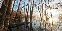
Minnesota Valley National Wildlife Area is a vast natural area along the southern edge of the Minnesota River in Burnsville, MN. The atmosphere of the area is always thick (as with most wetlands) even when fog isn't present. Here you can see rising the sun burning off water's morning fog.
Location
Lat: 44° 48' 2.1" N
Long: 94° 18' 1.51" W
Elevation: 696
Precision is: High. Pinpoints the exact spot.
Equipment
Canon EOS 20D DSLR, 8mm Fisheye Lens, ISO 100 @ f32, 1/4 sec., RAW
 Tap or click the zoom icon in the bottom right corner of the picture to switch between in-page and fullscreen view