

Loading panorama viewer ...
Configuring ...
© 2012 Roberto Mancuso,
Some Rights Reserved.

Caption
English:
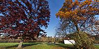
This place is called: "Wood in City" and is situated in Milan west. It is as important for our city as true forests are for the whole planet. Here you can see two particular trees and some old rural buildings, with zones available for people who come here for barbecues or to bring food and drinks to eat with their children: in fact this is the realm of children.
In the other pano I shot in the same wood you can see a little artificial lake.
Without these green spaces our cities would certainly be much less livable.
Italiano:
Questo posto e' chiamato: "Bosco in Citta')" ed e' situato nella parte ovest di Milano.E' importante per la nostra citta' quanto lo sono le vere foreste per l'intero pianeta. Qui potete vedere due alberi particolari ed alcune costruzioni rurali, con zone disponibili per le persone, che possono venire qui per il barbecue, o per portare cibi e bevande da mangiare con i loro figlioli:in pratica questo e un vero regno per i bambini. Senza queste zone verdi, la nostra citta' sarebbe certamente molto meno vivibile.
Location
Lat: 45° 28' 31" N
Long: 9° 5' 31" E
Elevation: 134 m s.l.m.
Precision is: Unknown / Undeclared.
Equipment
Camera: Nikon D70s, Lens: Nikkor 10.5mm fisheye, Panohead: Agno's TCP, Tripod: Feisol carbon fiber, Software PTGui, Photoshop.
 Tap or click the zoom icon in the bottom right corner of the picture to switch between in-page and fullscreen view