WWP Home arrow right This Event arrow right Indices: Alphabetical | Regional | Thumbnail | Map previousPrevious | Nextnext
event title
USA
portrait Alex Makienko
Village in the Forest
Ontario, Canada
mini manual

This should be a panorama image.

If you can read this, something went wrong.
We support these player technologies:

With ... you can view ...
Apple QuicktimeVR
(part of Quicktime)
all contributions
Adobe Flash Player 10.1 or newer most (not all, some contributions are QTVR-only due to historical reasons)
Javascript + HTML5 / WebGL many, but depends on photographer's choice of file upload (newer event = more likely to work) and your device's capabilities. You may experience slow playback, distorted images or unexpected browser quitting if there is only limited memory/GPU power available.
[?]
Copyright © 2011 Alex Makienko, All Rights Reserved
Hidden Canada
Previous panorama: Alex MakienkofullscreenA-Z Regions ThumbnlsShow in MapNext panorama: Roberto Mancuso

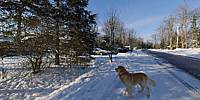
Willola Beach is a small settlement at the west end of the Ottawa Capital Region - the "Great Ottawa Area" which was formed about 11 years ago by extending the Canadian Capital borders. Now Ottawa borders include not only a city areas but also many farms and small villages. Willola Beach is one of them - a tiny village with ~50 houses and a few summer cottages in the forest on the Ottawa River shore. Downtown is far enough and nothing here reminds of a big city rush...

Location Map Geographic Coordinates:
Latitude: 45° 29' 32.72" N
Longitude: 76° 13' 41.09" W
Precision is: High. Pinpoints the exact spot.

arrow Show at MultiMap.com [what is MultiMap?]
arrow Show at Google Maps [what is Google Maps?]
arrow Show in Google Earth* [what is Google Earth?]
* requires Google Earth
installed on your computer

Date/Time:
January 30, 2011, 4:00 pm EST

Equipment:
Nikon D80, Nikkor 10.5mm f2.8, Stitching software: PanoLab3DX


WWP Home arrow right This Event arrow right Indices: Alphabetical | Regional | Thumbnail | Map previousPrevious | Nextnext