

Loading panorama viewer ...
Configuring ...
© 2011 Jozsef Urmos, All Rights Reserved.
Caption
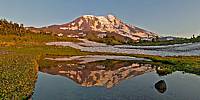
Lupine and other wildflowers fill the meadows framing a shallow alpine tarn, which perfectly mirrors a late summer sunset on Mt. Adams. Winter snowfields linger long at timberline here on the mountain's north slopes, especially after the unusually heavy snows of the previous winter. The icefall of the Adams Glacier is the most distinctive feature on the northwest face of the peak. The glacier steeply tumbles nearly 5,000 ft. from the summit snowfields in a chaotic jumble of snow and ice.
Mt. Adams is the second-highest peak in Washington state at an elevation of 12,277 ft. (3,742 m); it is also one of the largest volcanos in the Cascade Range of the Pacific Northwest.
Location
Lat: 46° 14' 25.92" N
Long: 122° 33' 9" W
Elevation: 6500 ft.
Precision is: High. Pinpoints the exact spot.
Equipment
PENTAX K20D, PENTAX DA 10-17mm at 10mm, Nodal Ninja 3, PTGui Pro.
 Tap or click the zoom icon in the bottom right corner of the picture to switch between in-page and fullscreen view