
The Vazhinka River near Sognitsy
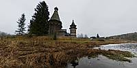
Sognitsy hamlet, Podporozhsky District, Leningrad Oblast, Russia
November 12, 2011, 10:21 UTC (14:21 local time)

Loading panorama viewer ...
Configuring ...
© 2011 Andrew Varlamov, All Rights Reserved.
Caption
The Vazhinka is a river in the Leningrad Oblast and the Republic of Karelia in Russia. It is a right tributary of the Svir River. It joins the Svir River 112 km away from the Svir's mouth. Its calculated length is 123 kilometers, the basin area of the river equals 2,200 km². The Wooden Church of St. Nicholas dominates over the river and over the Sogintsy hamlet. The church was built in 1696. It consists of an octagon church and a tented-roof belfry, connected by a church-porch.
Historians note that the composition of the Church of St. Nicholas is very close to the composition of the Church of the Transfiguration of Our Lord in the village of Pidma (lost after a fire during World War II).
(RU) Важинка - река в России, протекает в Ленинградской области и Республике Карелия, правый приток реки Свирь. Устье реки в посёлке Важины, оно находится в 112 км по правому берегу Свири, от устья последней. Длина реки составляет 123 км, площадь водосборного бассейна 2200 км².
Деревянная Никольская церковь возвышается над рекой и над деревней Согинцы. Построена она в 1696 году и представляет единую композицию из восьмигранной церкви с двумя прирубами — алтарем и притвором — и шатровой колокольни, соединенных между собой папертью.
Историки отмечают, что композиция церкви очень близка к композиции церкви Преображения Господня в Пидьме (сгоревшей в годы Великой Отечественной войны).
Equipment
Camera: Pentax K20DLens: smc PENTAX-DA Fish-Eye 1:3.5-4.5 10-17mm ED (IF)
Tripod: Manfrotto 190XB
Panohead: Nodal Ninja 5
PC Software: PTGui Pro 9.1.2 by New House Internet Services B.V. (dated by November 21, 2011), Pano2QTVR Pro Flash version 1.6.6 by Thomas Rauscher
Behind the scene : how this panorama was made
It was two-day bus trip organized by History Department of Saint Petersburg State University. Purpose of the travel was to visit wooden churches located in Leningrad Oblast between Lake Ladoga and Lake Onega. Other panoramas shooted during the travel describe in brief its route:
- Vazhiny near bridge across the Vazhinka river
- Voznesenie, traject across the Svir river
- Gimreka, Church of Nativity of the Theotokos (1695)
- Shcheleyki, Church of Demetrius of Thessaloniki (1783)
 Tap or click the zoom icon in the bottom right corner of the picture to switch between in-page and fullscreen view